Roșiori geodata
Roșiori (Mureş) is a populated place; located in Romania in Europe/Bucharest (GMT+3) time zone. With population of 849 people, there are 4845 cities with bigger population in this country. Compared to other cities in Romania, 67.3% of cities are located further ↓South; 67.9% of cities are located further →East and 65.5% of cities have lower elevation than Roșiori. Note1


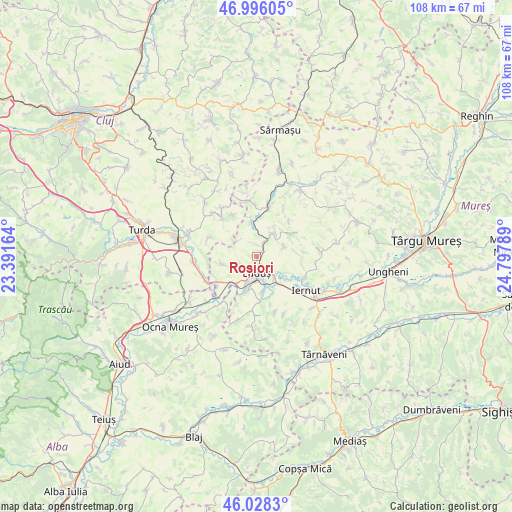
Roșiori GPS coordinates[2]
46° 30' 51.588" North, 24° 5' 41.136" East
| Map corner | latitude | longitude |
|---|---|---|
| Upper-left | 46.99605°, | 23.39164° |
| Center: | 46.51433°, | 24.09476° |
| Lower-right: | 46.0283°, | 24.79789° |
| Map W x H: | 107.6×107.6 km | = 66.9×66.9mi |
| max Lat: | 48.23793° ⇑32.7% North |
| Roșiori: | 46.51433° |
| min Lat: | ⇓67.3% South 43.65638° |
| min Long | Roșiori | max Long |
| 20.31667° | 24.09476° | 29.65403° |
| W 32.1%⇐ | ⇒67.9% E |
Elevation
Elevation of Roșiori is 293 m = 961 ft, and this is 38.1 m = 125 ft above average elevation for this country.
| Max E: |
1278 m = 4193 ft | 34.5% |
| Roșiori | 293 m 961 ft | |
| Avg. | 254.9 m = 836 ft | |
Min E: |
-2 m = -7 ft | 65.5% |
See also: Romania elevation on elevation.city.
Geographical zone
Roșiori is located in North temperate zone (between Tropic of Cancer and the Arctic Circle). Distance of this North polar circle is 2229.3 km =1385.2 mi to North.| Distance of | km | miles | from Roșiori |
|---|---|---|---|
| North Pole | 4835.2 | 3004.5 | to North |
| Arctic Circle | 2229.3 | 1385.2 | to North |
| Tropic Cancer | 2566 | 1594.4 | to South |
| Equator | 5171.9 | 3213.7 | to South |


Nearby cities:
15 places around Roșiori: (largest is in red/bold)
• Aţintiş
9 km =5.6 mi,  177°
177°
• Bogata
7.5 km =4.7 mi,  196°
196°
• Bârza
4.9 km =3 mi,  36°
36°
• Cheţani
7.1 km =4.4 mi,  221°
221°
• Cipăieni
5.9 km =3.7 mi,  70°
70°
• Cuci
6.8 km =4.2 mi,  141°
141°
• Gheja
7.8 km =4.8 mi, 197°
• Grindeni
7.6 km =4.7 mi,  258°
258°
• Hădăreni
10 km =6.2 mi,  238°
238°
• Luduş
3.5 km =2.2 mi,  173°
173°
• Papiu Ilarian
9 km =5.6 mi,  63°
63°
• Pădureni
10.2 km =6.3 mi,  329°
329°
• Sânger
5.9 km =3.7 mi,  33°
33°
• Tritenii de Jos
10.6 km =6.6 mi,  316°
316°
• Tăureni
7.3 km =4.5 mi,  351°
351°
Sources, notices
• [Note1] Compared only with cities in Romania existing in our database
• [Src1] Map data: © OpenStreetMap contributors (CC-BY-SA)
• [Src2] Other city data from geonames.org with taken over terms of usage.
• [Src3] Geographical zone / Annual Mean Temperature by Robert A. Rohde @ Wikipedia
