Luduş geodata
Luduş (Mureş) is a seat of a second-order administrative division; located in Romania in Europe/Bucharest (GMT+3) time zone. With population of 17,165 people, there are 117 cities with bigger population in this country. Compared to other cities in Romania, 66.7% of cities are located further ↓South; 67.8% of cities are located further →East and 61.5% of cities have lower elevation than Luduş. Note1


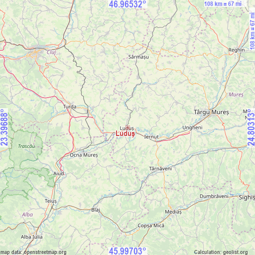
Luduş GPS coordinates[2]
46° 28' 59.988" North, 24° 6' 0" East
| Map corner | latitude | longitude |
|---|---|---|
| Upper-left | 46.96532°, | 23.39688° |
| Center: | 46.48333°, | 24.1° |
| Lower-right: | 45.99703°, | 24.80313° |
| Map W x H: | 107.7×107.7 km | = 66.9×66.9mi |
| max Lat: | 48.23793° ⇑33.3% North |
| Luduş: | 46.48333° |
| min Lat: | ⇓66.7% South 43.65638° |
| min Long | Luduş | max Long |
| 20.31667° | 24.1° | 29.65403° |
| W 32.2%⇐ | ⇒67.8% E |
Elevation
Elevation of Luduş is 272 m = 892 ft, and this is 17.1 m = 56 ft above average elevation for this country.
| Max E: |
1278 m = 4193 ft | 38.5% |
| Luduş | 272 m 892 ft | |
| Avg. | 254.9 m = 836 ft | |
Min E: |
-2 m = -7 ft | 61.5% |
See also: Romania elevation on elevation.city.
Geographical zone
Luduş is located in North temperate zone (between Tropic of Cancer and the Arctic Circle). Distance of this North polar circle is 2232.7 km =1387.3 mi to North.| Distance of | km | miles | from Luduş |
|---|---|---|---|
| North Pole | 4838.6 | 3006.6 | to North |
| Arctic Circle | 2232.7 | 1387.3 | to North |
| Tropic Cancer | 2562.5 | 1592.3 | to South |
| Equator | 5168.5 | 3211.6 | to South |


Nearby cities:
15 places around Luduş: (largest is in red/bold)
• Aţintiş
5.6 km =3.5 mi,  180°
180°
• Bogata
4.5 km =2.8 mi,  214°
214°
• Bârza
7.8 km =4.8 mi,  18°
18°
• Cheţani
5.4 km =3.4 mi,  250°
250°
• Cipăieni
7.5 km =4.7 mi,  43°
43°
• Cuci
4.3 km =2.7 mi,  115°
115°
• Gheja
4.8 km =3 mi, 213°
• Gligorești
10.2 km =6.3 mi, 247°
• Grindeni
8 km =5 mi,  283°
283°
• Hădăreni
9.1 km =5.7 mi,  258°
258°
• Lechința
9.9 km =6.2 mi,  95°
95°
• Petrilaca
8.8 km =5.5 mi,  156°
156°
• Roșiori
3.5 km =2.2 mi,  353°
353°
• Sânger
8.8 km =5.5 mi, 19°
• Sălcud
10 km =6.2 mi,  147°
147°
Sources, notices
• [Note1] Compared only with cities in Romania existing in our database
• [Src1] Map data: © OpenStreetMap contributors (CC-BY-SA)
• [Src2] Other city data from geonames.org with taken over terms of usage.
• [Src3] Geographical zone / Annual Mean Temperature by Robert A. Rohde @ Wikipedia
