Gheja geodata
Gheja (Mureş) is a populated place; located in Romania in Europe/Bucharest (GMT+3) time zone. With population of 1,429 people, there are 3288 cities with bigger population in this country. Compared to other cities in Romania, 65.7% of cities are located further ↓South; 68.3% of cities are located further →East and 61.5% of cities have lower elevation than Gheja. Note1


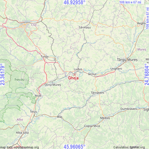
Gheja GPS coordinates[2]
46° 26' 50.172" North, 24° 3' 53.676" East
| Map corner | latitude | longitude |
|---|---|---|
| Upper-left | 46.92958°, | 23.36179° |
| Center: | 46.44727°, | 24.06491° |
| Lower-right: | 45.96065°, | 24.76804° |
| Map W x H: | 107.7×107.7 km | = 66.9×66.9mi |
| max Lat: | 48.23793° ⇑34.3% North |
| Gheja: | 46.44727° |
| min Lat: | ⇓65.7% South 43.65638° |
| min Long | Gheja | max Long |
| 20.31667° | 24.06491° | 29.65403° |
| W 31.7%⇐ | ⇒68.3% E |
Elevation
Elevation of Gheja is 272 m = 892 ft, and this is 17.1 m = 56 ft above average elevation for this country.
| Max E: |
1278 m = 4193 ft | 38.5% |
| Gheja | 272 m 892 ft | |
| Avg. | 254.9 m = 836 ft | |
Min E: |
-2 m = -7 ft | 61.5% |
See also: Romania elevation on elevation.city.
Geographical zone
Gheja is located in North temperate zone (between Tropic of Cancer and the Arctic Circle). Distance of this North polar circle is 2236.7 km =1389.8 mi to North.| Distance of | km | miles | from Gheja |
|---|---|---|---|
| North Pole | 4842.6 | 3009.1 | to North |
| Arctic Circle | 2236.7 | 1389.8 | to North |
| Tropic Cancer | 2558.5 | 1589.8 | to South |
| Equator | 5164.5 | 3209.1 | to South |


Nearby cities:
15 places around Gheja: (largest is in red/bold)
• Aţintiş
3.1 km =1.9 mi,  119°
119°
• Bichiş
9.4 km =5.8 mi,  163°
163°
• Bogata
0.3 km =0.2 mi,  23°
23°
• Cheţani
3.2 km =2 mi,  311°
311°
• Cuci
6.9 km =4.3 mi,  71°
71°
• Gligorești
6.8 km =4.2 mi,  270°
270°
• Grindeni
7.8 km =4.8 mi,  319°
319°
• Gura Arieșului
8.5 km =5.3 mi,  256°
256°
• Hădăreni
6.6 km =4.1 mi,  289°
289°
• Luduş
4.8 km =3 mi,  33°
33°
• Luncani
9.2 km =5.7 mi, 287°
• Noşlac
11.4 km =7.1 mi,  242°
242°
• Petrilaca
7.5 km =4.7 mi, 122°
• Roșiori
7.8 km =4.8 mi, 17°
• Sălcud
9.3 km =5.8 mi, 118°
Sources, notices
• [Note1] Compared only with cities in Romania existing in our database
• [Src1] Map data: © OpenStreetMap contributors (CC-BY-SA)
• [Src2] Other city data from geonames.org with taken over terms of usage.
• [Src3] Geographical zone / Annual Mean Temperature by Robert A. Rohde @ Wikipedia
