Roşia de Secaş geodata
Roşia de Secaş (Alba) is a seat of a second-order administrative division; located in Romania in Europe/Bucharest (GMT+3) time zone. With population of 1,660 people, there are 2969 cities with bigger population in this country. Compared to other cities in Romania, 56% of cities are located further ↓South; 71.4% of cities are located further →East and 69.2% of cities have lower elevation than Roşia de Secaş. Note1


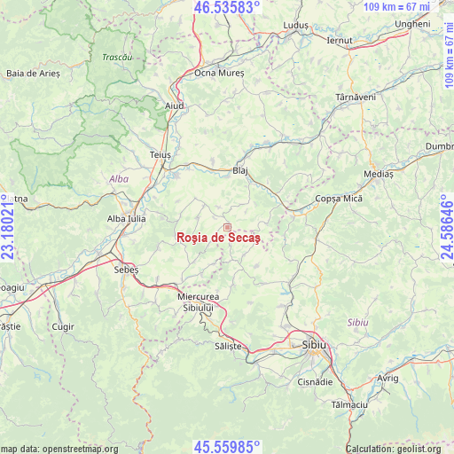
Roşia de Secaş GPS coordinates[2]
46° 3' 0" North, 23° 52' 59.988" East
| Map corner | latitude | longitude |
|---|---|---|
| Upper-left | 46.53583°, | 23.18021° |
| Center: | 46.05°, | 23.88333° |
| Lower-right: | 45.55985°, | 24.58646° |
| Map W x H: | 108.5×108.5 km | = 67.4×67.4mi |
| max Lat: | 48.23793° ⇑44% North |
| Roşia de Secaş: | 46.05° |
| min Lat: | ⇓56% South 43.65638° |
| min Long | Roşia de Seca� | max Long |
| 20.31667° | 23.88333° | 29.65403° |
| W 28.6%⇐ | ⇒71.4% E |
Elevation
Elevation of Roşia de Secaş is 314 m = 1030 ft, and this is 59.1 m = 194 ft above average elevation for this country.
| Max E: |
1278 m = 4193 ft | 30.8% |
| Roşia de Secaş | 314 m 1030 ft | |
| Avg. | 254.9 m = 836 ft | |
Min E: |
-2 m = -7 ft | 69.2% |
See also: Romania elevation on elevation.city.
Geographical zone
Roşia de Secaş is located in North temperate zone (between Tropic of Cancer and the Arctic Circle). Distance of this North polar circle is 2280.9 km =1417.3 mi to North.| Distance of | km | miles | from Roşia de Secaş |
|---|---|---|---|
| North Pole | 4886.8 | 3036.5 | to North |
| Arctic Circle | 2280.9 | 1417.3 | to North |
| Tropic Cancer | 2514.4 | 1562.4 | to South |
| Equator | 5120.3 | 3181.6 | to South |


Nearby cities:
15 places around Roşia de Secaş: (largest is in red/bold)
• Armeni
11.7 km =7.3 mi,  142°
142°
• Berghin
11.7 km =7.3 mi,  285°
285°
• Cenade
10.3 km =6.4 mi,  90°
90°
• Cergău Mare
6.2 km =3.9 mi,  29°
29°
• Cergău Mic
5.3 km =3.3 mi,  46°
46°
• Doştat
9.6 km =6 mi,  195°
195°
• Ghirbom
12.5 km =7.8 mi,  262°
262°
• Mănărade
12.1 km =7.5 mi, 32°
• Ohaba
7.9 km =4.9 mi,  283°
283°
• Presaca
8.3 km =5.2 mi,  176°
176°
• Păuca
3.9 km =2.4 mi,  160°
160°
• Tiur
12.2 km =7.6 mi,  2°
2°
• Tău
3.9 km =2.4 mi,  305°
305°
• Vingard
11.3 km =7 mi,  248°
248°
• Şpring
12.1 km =7.5 mi,  219°
219°
Sources, notices
• [Note1] Compared only with cities in Romania existing in our database
• [Src1] Map data: © OpenStreetMap contributors (CC-BY-SA)
• [Src2] Other city data from geonames.org with taken over terms of usage.
• [Src3] Geographical zone / Annual Mean Temperature by Robert A. Rohde @ Wikipedia
