Vingard geodata
Vingard (Alba) is a populated place; located in Romania in Europe/Bucharest (GMT+3) time zone. With population of 696 people, there are 5602 cities with bigger population in this country. Compared to other cities in Romania, 55.3% of cities are located further ↓South; 73.5% of cities are located further →East and 77.9% of cities have lower elevation than Vingard. Note1


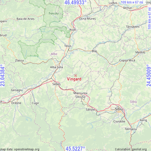
Vingard GPS coordinates[2]
46° 0' 47.412" North, 23° 44' 49.056" East
| Map corner | latitude | longitude |
|---|---|---|
| Upper-left | 46.49933°, | 23.04384° |
| Center: | 46.01317°, | 23.74696° |
| Lower-right: | 45.5227°, | 24.45009° |
| Map W x H: | 108.6×108.6 km | = 67.5×67.5mi |
| max Lat: | 48.23793° ⇑44.7% North |
| Vingard: | 46.01317° |
| min Lat: | ⇓55.3% South 43.65638° |
| min Long | Vingard | max Long |
| 20.31667° | 23.74696° | 29.65403° |
| W 26.5%⇐ | ⇒73.5% E |
Elevation
Elevation of Vingard is 375 m = 1230 ft, and this is 120.1 m = 394 ft above average elevation for this country.
| Max E: |
1278 m = 4193 ft | 22.1% |
| Vingard | 375 m 1230 ft | |
| Avg. | 254.9 m = 836 ft | |
Min E: |
-2 m = -7 ft | 77.9% |
See also: Romania elevation on elevation.city.
Geographical zone
Vingard is located in North temperate zone (between Tropic of Cancer and the Arctic Circle). Distance of this North polar circle is 2285 km =1419.8 mi to North.| Distance of | km | miles | from Vingard |
|---|---|---|---|
| North Pole | 4890.9 | 3039.1 | to North |
| Arctic Circle | 2285 | 1419.8 | to North |
| Tropic Cancer | 2510.3 | 1559.8 | to South |
| Equator | 5116.2 | 3179.1 | to South |


Nearby cities:
15 places around Vingard: (largest is in red/bold)
• Berghin
7.2 km =4.5 mi,  354°
354°
• Ciugud
10.9 km =6.8 mi,  292°
292°
• Cunța
10 km =6.2 mi,  190°
190°
• Cut
10.2 km =6.3 mi,  217°
217°
• Daia Română
6.2 km =3.9 mi,  273°
273°
• Doştat
9.5 km =5.9 mi,  123°
123°
• Drașov
8.3 km =5.2 mi,  181°
181°
• Ghirbom
3 km =1.9 mi,  322°
322°
• Henig
10.4 km =6.5 mi, 353°
• Ohaba
6.6 km =4.1 mi,  25°
25°
• Păuca
11.8 km =7.3 mi,  88°
88°
• Roşia de Secaş
11.3 km =7 mi,  68°
68°
• Tău
9.7 km =6 mi,  48°
48°
• Şpring
5.9 km =3.7 mi,  151°
151°
• Șeușa
10.6 km =6.6 mi,  299°
299°
Sources, notices
• [Note1] Compared only with cities in Romania existing in our database
• [Src1] Map data: © OpenStreetMap contributors (CC-BY-SA)
• [Src2] Other city data from geonames.org with taken over terms of usage.
• [Src3] Geographical zone / Annual Mean Temperature by Robert A. Rohde @ Wikipedia
