Râca geodata
Râca (Arges) is a seat of a second-order administrative division; located in Romania in Europe/Bucharest (GMT+3) time zone. With population of 866 people, there are 4767 cities with bigger population in this country. Compared to other cities in Romania, 87.2% of cities are located further ↑North; 52.1% of cities are located further →East and 60.1% of cities have higher elevation than Râca. Note1


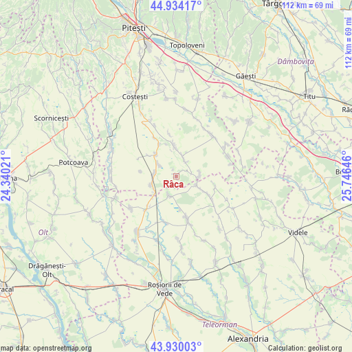
Râca GPS coordinates[2]
44° 26' 3.336" North, 25° 2' 35.988" East
| Map corner | latitude | longitude |
|---|---|---|
| Upper-left | 44.93417°, | 24.34021° |
| Center: | 44.43426°, | 25.04333° |
| Lower-right: | 43.93003°, | 25.74646° |
| Map W x H: | 111.6×111.6 km | = 69.3×69.3mi |
| max Lat: | 48.23793° ⇑87.2% North |
| Râca: | 44.43426° |
| min Lat: | ⇓12.8% South 43.65638° |
| min Long | Râca | max Long |
| 20.31667° | 25.04333° | 29.65403° |
| W 47.9%⇐ | ⇒52.1% E |
Elevation
Elevation of Râca is 166 m = 545 ft, and this is 88.9 m = 292 ft below average elevation for this country.
| Max E: |
1278 m = 4193 ft | 60.1% |
| Avg. | 254.9 m = 836 ft | |
| Râca | 166 m = 545 ft | |
Min E: |
-2 m = -7 ft | 39.9% |
See also: Romania elevation on elevation.city.
Geographical zone
Râca is located in North temperate zone (between Tropic of Cancer and the Arctic Circle). Distance of this Northern Tropic circle is 2334.7 km =1450.7 mi to South.| Distance of | km | miles | from Râca |
|---|---|---|---|
| North Pole | 5066.4 | 3148.1 | to North |
| Arctic Circle | 2460.5 | 1528.9 | to North |
| Tropic Cancer | 2334.7 | 1450.7 | to South |
| Equator | 4940.6 | 3069.9 | to South |


Nearby cities:
15 places around Râca: (largest is in red/bold)
• Baldovinești
10.5 km =6.5 mi,  173°
173°
• Colțu
11.2 km =7 mi,  306°
306°
• Căldăraru
7.6 km =4.7 mi,  283°
283°
• Dobreni
6.1 km =3.8 mi,  108°
108°
• Izvoru
6.9 km =4.3 mi,  14°
14°
• Miroşi
9 km =5.6 mi,  257°
257°
• Popeşti
4.6 km =2.9 mi,  79°
79°
• Purcăreni
7.4 km =4.6 mi, 79°
• Siliștea Gumești
6.6 km =4.1 mi,  211°
211°
• Slobozia
6.9 km =4.3 mi,  89°
89°
• Strâmbeni
6.8 km =4.2 mi,  304°
304°
• Surdulești
8.2 km =5.1 mi,  235°
235°
• Tătărăștii de Sus
6.9 km =4.3 mi,  115°
115°
• Udupu
9.1 km =5.7 mi, 117°
• Ungheni
9.5 km =5.9 mi,  320°
320°
Sources, notices
• [Note1] Compared only with cities in Romania existing in our database
• [Src1] Map data: © OpenStreetMap contributors (CC-BY-SA)
• [Src2] Other city data from geonames.org with taken over terms of usage.
• [Src3] Geographical zone / Annual Mean Temperature by Robert A. Rohde @ Wikipedia
