Slobozia geodata
Slobozia (Arges) is a populated place; located in Romania in Europe/Bucharest (GMT+3) time zone. With population of 997 people, there are 4304 cities with bigger population in this country. Compared to other cities in Romania, 87.2% of cities are located further ↑North; 51% of cities are located further →East and 63.2% of cities have higher elevation than Slobozia. Note1


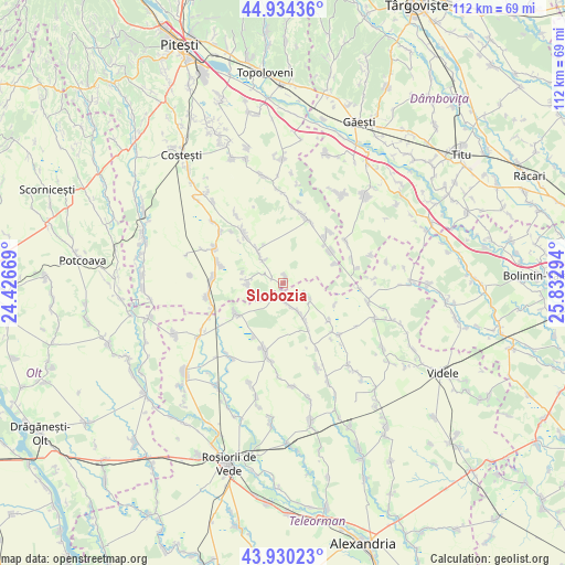
Slobozia GPS coordinates[2]
44° 26' 4.02" North, 25° 7' 47.316" East
| Map corner | latitude | longitude |
|---|---|---|
| Upper-left | 44.93436°, | 24.42669° |
| Center: | 44.43445°, | 25.12981° |
| Lower-right: | 43.93023°, | 25.83294° |
| Map W x H: | 111.6×111.6 km | = 69.3×69.3mi |
| max Lat: | 48.23793° ⇑87.2% North |
| Slobozia: | 44.43445° |
| min Lat: | ⇓12.8% South 43.65638° |
| min Long | Slobozia | max Long |
| 20.31667° | 25.12981° | 29.65403° |
| W 49%⇐ | ⇒51% E |
Elevation
Elevation of Slobozia is 154 m = 505 ft, and this is 100.9 m = 331 ft below average elevation for this country.
| Max E: |
1278 m = 4193 ft | 63.2% |
| Avg. | 254.9 m = 836 ft | |
| Slobozia | 154 m = 505 ft | |
Min E: |
-2 m = -7 ft | 36.8% |
See also: Romania elevation on elevation.city.
Geographical zone
Slobozia is located in North temperate zone (between Tropic of Cancer and the Arctic Circle). Distance of this Northern Tropic circle is 2334.7 km =1450.7 mi to South.| Distance of | km | miles | from Slobozia |
|---|---|---|---|
| North Pole | 5066.4 | 3148.1 | to North |
| Arctic Circle | 2460.5 | 1528.9 | to North |
| Tropic Cancer | 2334.7 | 1450.7 | to South |
| Equator | 4940.6 | 3069.9 | to South |


Nearby cities:
15 places around Slobozia: (largest is in red/bold)
• Dobreni
2.2 km =1.4 mi,  207°
207°
• Drăcești
11.8 km =7.3 mi,  129°
129°
• Izvoru
8.4 km =5.2 mi,  322°
322°
• Negreni
5.9 km =3.7 mi,  117°
117°
• Negrenii de Sus
4.8 km =3 mi,  110°
110°
• Popeşti
2.5 km =1.6 mi,  289°
289°
• Poporogi
8.7 km =5.4 mi,  150°
150°
• Purcăreni
1.4 km =0.9 mi,  15°
15°
• Râca
6.9 km =4.3 mi,  269°
269°
• Siliștea Gumești
11.8 km =7.3 mi,  241°
241°
• Slăvești
11.7 km =7.3 mi, 152°
• Tătărăștii de Jos
7.6 km =4.7 mi, 150°
• Tătărăștii de Sus
3 km =1.9 mi,  191°
191°
• Udupu
4.4 km =2.7 mi,  164°
164°
• Ştefan cel Mare
11.2 km =7 mi,  54°
54°
Sources, notices
• [Note1] Compared only with cities in Romania existing in our database
• [Src1] Map data: © OpenStreetMap contributors (CC-BY-SA)
• [Src2] Other city data from geonames.org with taken over terms of usage.
• [Src3] Geographical zone / Annual Mean Temperature by Robert A. Rohde @ Wikipedia
