Satnoeni geodata
Satnoeni (Călăraşi) is a populated place; located in Romania in Europe/Bucharest (GMT+3) time zone. With population of 574 people, there are 6394 cities with bigger population in this country. Compared to other cities in Romania, 92.6% of cities are located further ↑North; 91.6% of cities are located further ←West and 97.5% of cities have higher elevation than Satnoeni. Note1


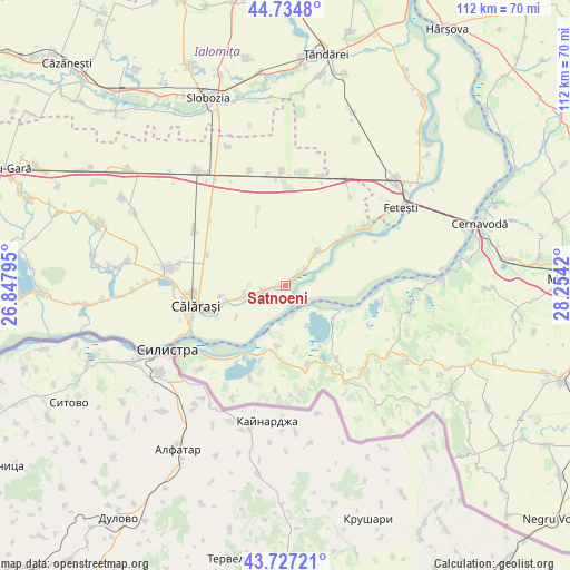
Satnoeni GPS coordinates[2]
44° 13' 59.376" North, 27° 33' 3.852" East
| Map corner | latitude | longitude |
|---|---|---|
| Upper-left | 44.7348°, | 26.84795° |
| Center: | 44.23316°, | 27.55107° |
| Lower-right: | 43.72721°, | 28.2542° |
| Map W x H: | 112×112 km | = 69.6×69.6mi |
| max Lat: | 48.23793° ⇑92.6% North |
| Satnoeni: | 44.23316° |
| min Lat: | ⇓7.4% South 43.65638° |
| min Long | Satnoeni | max Long |
| 20.31667° | 27.55107° | 29.65403° |
| W 91.6%⇐ | ⇒8.4% E |
Elevation
Elevation of Satnoeni is 20 m = 66 ft, and this is 234.9 m = 771 ft below average elevation for this country.
| Max E: |
1278 m = 4193 ft | 97.5% |
| Avg. | 254.9 m = 836 ft | |
| Satnoeni | 20 m = 66 ft | |
Min E: |
-2 m = -7 ft | 2.5% |
See also: Romania elevation on elevation.city.
Geographical zone
Satnoeni is located in North temperate zone (between Tropic of Cancer and the Arctic Circle). Distance of this Northern Tropic circle is 2312.3 km =1436.8 mi to South.| Distance of | km | miles | from Satnoeni |
|---|---|---|---|
| North Pole | 5088.8 | 3162 | to North |
| Arctic Circle | 2482.9 | 1542.8 | to North |
| Tropic Cancer | 2312.3 | 1436.8 | to South |
| Equator | 4918.3 | 3056.1 | to South |


Nearby cities:
15 places around Satnoeni: (largest is in red/bold)
• Canlia
12.1 km =7.5 mi,  188°
188°
• Coslugea
12.9 km =8 mi,  170°
170°
• Călăraşi
19.2 km =11.9 mi,  260°
260°
• Dichiseni
1.4 km =0.9 mi,  270°
270°
• Galița
15.6 km =9.7 mi,  197°
197°
• Gâldău
12.4 km =7.7 mi,  49°
49°
• Iezeru
8.3 km =5.2 mi,  44°
44°
• Jegălia
9.9 km =6.2 mi, 41°
• Lipniţa
15.3 km =9.5 mi, 165°
• Modelu
13.7 km =8.5 mi,  252°
252°
• Oltina
11.8 km =7.3 mi,  128°
128°
• Roseţi
8.4 km =5.2 mi, 255°
• Răzoarele
17.9 km =11.1 mi,  144°
144°
• Unirea
7.5 km =4.7 mi,  60°
60°
• Viile
18.3 km =11.4 mi,  115°
115°
Sources, notices
• [Note1] Compared only with cities in Romania existing in our database
• [Src1] Map data: © OpenStreetMap contributors (CC-BY-SA)
• [Src2] Other city data from geonames.org with taken over terms of usage.
• [Src3] Geographical zone / Annual Mean Temperature by Robert A. Rohde @ Wikipedia
