Rafaila geodata
Rafaila (Vaslui) is a seat of a second-order administrative division; located in Romania in Europe/Bucharest (GMT+3) time zone. With population of 1,908 people, there are 2694 cities with bigger population in this country. Compared to other cities in Romania, 74.2% of cities are located further ↓South; 89.1% of cities are located further ←West and 69% of cities have lower elevation than Rafaila. Note1


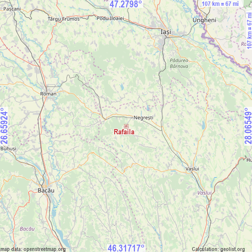
Rafaila GPS coordinates[2]
46° 48' 2.304" North, 27° 21' 44.496" East
| Map corner | latitude | longitude |
|---|---|---|
| Upper-left | 47.2798°, | 26.65924° |
| Center: | 46.80064°, | 27.36236° |
| Lower-right: | 46.31717°, | 28.06549° |
| Map W x H: | 107×107 km | = 66.5×66.5mi |
| max Lat: | 48.23793° ⇑25.8% North |
| Rafaila: | 46.80064° |
| min Lat: | ⇓74.2% South 43.65638° |
| min Long | Rafaila | max Long |
| 20.31667° | 27.36236° | 29.65403° |
| W 89.1%⇐ | ⇒10.9% E |
Elevation
Elevation of Rafaila is 312 m = 1024 ft, and this is 57.1 m = 187 ft above average elevation for this country.
| Max E: |
1278 m = 4193 ft | 31% |
| Rafaila | 312 m 1024 ft | |
| Avg. | 254.9 m = 836 ft | |
Min E: |
-2 m = -7 ft | 69% |
See also: Romania elevation on elevation.city.
Geographical zone
Rafaila is located in North temperate zone (between Tropic of Cancer and the Arctic Circle). Distance of this North polar circle is 2197.4 km =1365.4 mi to North.| Distance of | km | miles | from Rafaila |
|---|---|---|---|
| North Pole | 4803.3 | 2984.6 | to North |
| Arctic Circle | 2197.4 | 1365.4 | to North |
| Tropic Cancer | 2597.8 | 1614.2 | to South |
| Equator | 5203.7 | 3233.4 | to South |


Nearby cities:
15 places around Rafaila: (largest is in red/bold)
• Buda
6.2 km =3.9 mi,  133°
133°
• Băceşti
11.2 km =7 mi,  299°
299°
• Dumeşti
8.1 km =5 mi,  312°
312°
• Fâstâci
10.2 km =6.3 mi,  139°
139°
• Gârceni
7.1 km =4.4 mi,  237°
237°
• Huc
4.6 km =2.9 mi,  47°
47°
• Jigoreni
11.3 km =7 mi,  341°
341°
• Negreşti
6.5 km =4 mi,  56°
56°
• Oşeşti
8.8 km =5.5 mi,  115°
115°
• Parpanița
10.2 km =6.3 mi,  69°
69°
• Pungeşti
11.4 km =7.1 mi,  191°
191°
• Todireşti
5.5 km =3.4 mi,  3°
3°
• Toporăști
12.5 km =7.8 mi,  162°
162°
• Valea Mare
4.4 km =2.7 mi,  323°
323°
• Valea Mare
7.5 km =4.7 mi,  78°
78°
Sources, notices
• [Note1] Compared only with cities in Romania existing in our database
• [Src1] Map data: © OpenStreetMap contributors (CC-BY-SA)
• [Src2] Other city data from geonames.org with taken over terms of usage.
• [Src3] Geographical zone / Annual Mean Temperature by Robert A. Rohde @ Wikipedia
