Rădeşti geodata
Rădeşti (Alba) is a seat of a second-order administrative division; located in Romania in Europe/Bucharest (GMT+3) time zone. With population of 1,379 people, there are 3378 cities with bigger population in this country. Compared to other cities in Romania, 61.1% of cities are located further ↓South; 74.1% of cities are located further →East and 54% of cities have lower elevation than Rădeşti. Note1


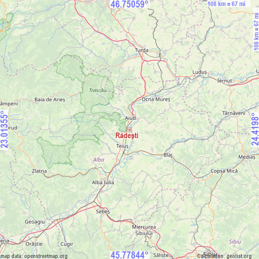
Rădeşti GPS coordinates[2]
46° 16' 0.012" North, 23° 43' 0.012" East
| Map corner | latitude | longitude |
|---|---|---|
| Upper-left | 46.75059°, | 23.01355° |
| Center: | 46.26667°, | 23.71667° |
| Lower-right: | 45.77844°, | 24.4198° |
| Map W x H: | 108.1×108.1 km | = 67.2×67.2mi |
| max Lat: | 48.23793° ⇑38.9% North |
| Rădeşti: | 46.26667° |
| min Lat: | ⇓61.1% South 43.65638° |
| min Long | Rădeşti | max Long |
| 20.31667° | 23.71667° | 29.65403° |
| W 25.9%⇐ | ⇒74.1% E |
Elevation
Elevation of Rădeşti is 233 m = 764 ft, and this is 21.9 m = 72 ft below average elevation for this country.
| Max E: |
1278 m = 4193 ft | 46% |
| Avg. | 254.9 m = 836 ft | |
| Rădeşti | 233 m = 764 ft | |
Min E: |
-2 m = -7 ft | 54% |
See also: Romania elevation on elevation.city.
Geographical zone
Rădeşti is located in North temperate zone (between Tropic of Cancer and the Arctic Circle). Distance of this North polar circle is 2256.8 km =1402.3 mi to North.| Distance of | km | miles | from Rădeşti |
|---|---|---|---|
| North Pole | 4862.7 | 3021.5 | to North |
| Arctic Circle | 2256.8 | 1402.3 | to North |
| Tropic Cancer | 2538.5 | 1577.4 | to South |
| Equator | 5144.4 | 3196.6 | to South |


Nearby cities:
15 places around Rădeşti: (largest is in red/bold)
• Aiud
4.8 km =3 mi,  4°
4°
• Aiudul de Sus
5.9 km =3.7 mi,  340°
340°
• Beța
7.7 km =4.8 mi,  100°
100°
• Băgău
7.7 km =4.8 mi,  50°
50°
• Cetea
10.6 km =6.6 mi,  252°
252°
• Cistei
9.3 km =5.8 mi,  162°
162°
• Ciumbrud
5.8 km =3.6 mi,  37°
37°
• Geoagiu de Sus
9.6 km =6 mi,  261°
261°
• Lopadea Nouă
8.3 km =5.2 mi,  71°
71°
• Mirăslău
11.1 km =6.9 mi, 0°
• Măgina
9.7 km =6 mi,  328°
328°
• Obreja
10.9 km =6.8 mi, 159°
• Stremţ
8.5 km =5.3 mi,  229°
229°
• Sâncrai
4.1 km =2.5 mi, 41°
• Teiuş
7.8 km =4.8 mi,  199°
199°
Sources, notices
• [Note1] Compared only with cities in Romania existing in our database
• [Src1] Map data: © OpenStreetMap contributors (CC-BY-SA)
• [Src2] Other city data from geonames.org with taken over terms of usage.
• [Src3] Geographical zone / Annual Mean Temperature by Robert A. Rohde @ Wikipedia
