Stremţ geodata
Stremţ (Alba) is a seat of a second-order administrative division; located in Romania in Europe/Bucharest (GMT+3) time zone. With population of 2,761 people, there are 1936 cities with bigger population in this country. Compared to other cities in Romania, 59.9% of cities are located further ↓South; 75.2% of cities are located further →East and 72.5% of cities have lower elevation than Stremţ. Note1


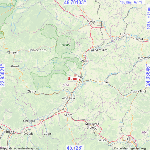
Stremţ GPS coordinates[2]
46° 13' 0.012" North, 23° 37' 59.988" East
| Map corner | latitude | longitude |
|---|---|---|
| Upper-left | 46.70103°, | 22.93021° |
| Center: | 46.21667°, | 23.63333° |
| Lower-right: | 45.728°, | 24.33646° |
| Map W x H: | 108.2×108.2 km | = 67.2×67.2mi |
| max Lat: | 48.23793° ⇑40.1% North |
| Stremţ: | 46.21667° |
| min Lat: | ⇓59.9% South 43.65638° |
| min Long | Stremţ | max Long |
| 20.31667° | 23.63333° | 29.65403° |
| W 24.8%⇐ | ⇒75.2% E |
Elevation
Elevation of Stremţ is 337 m = 1106 ft, and this is 82.1 m = 269 ft above average elevation for this country.
| Max E: |
1278 m = 4193 ft | 27.5% |
| Stremţ | 337 m 1106 ft | |
| Avg. | 254.9 m = 836 ft | |
Min E: |
-2 m = -7 ft | 72.5% |
See also: Romania elevation on elevation.city.
Geographical zone
Stremţ is located in North temperate zone (between Tropic of Cancer and the Arctic Circle). Distance of this North polar circle is 2262.4 km =1405.8 mi to North.| Distance of | km | miles | from Stremţ |
|---|---|---|---|
| North Pole | 4868.2 | 3025 | to North |
| Arctic Circle | 2262.4 | 1405.8 | to North |
| Tropic Cancer | 2532.9 | 1573.9 | to South |
| Equator | 5138.8 | 3193.1 | to South |


Nearby cities:
15 places around Stremţ: (largest is in red/bold)
• Benic
3.2 km =2 mi,  263°
263°
• Bucerdea Vinoasă
10 km =6.2 mi,  233°
233°
• Cetea
4.4 km =2.7 mi,  302°
302°
• Cistei
9.8 km =6.1 mi,  109°
109°
• Cricău
6.3 km =3.9 mi, 234°
• Galda de Jos
3.9 km =2.4 mi,  199°
199°
• Geoagiu de Sus
5.2 km =3.2 mi,  323°
323°
• Ighiu
11.6 km =7.2 mi, 230°
• Mihalţ
10.7 km =6.6 mi,  133°
133°
• Obreja
11.2 km =7 mi, 114°
• Oiejdea
6.5 km =4 mi,  179°
179°
• Rădeşti
8.5 km =5.3 mi,  49°
49°
• Sântimbru
9.4 km =5.8 mi,  172°
172°
• Teiuş
4.3 km =2.7 mi,  115°
115°
• Totoi
11.5 km =7.1 mi, 170°
Sources, notices
• [Note1] Compared only with cities in Romania existing in our database
• [Src1] Map data: © OpenStreetMap contributors (CC-BY-SA)
• [Src2] Other city data from geonames.org with taken over terms of usage.
• [Src3] Geographical zone / Annual Mean Temperature by Robert A. Rohde @ Wikipedia
