Răchițele geodata
Răchițele (Cluj) is a populated place; located in Romania in Europe/Bucharest (GMT+3) time zone. With population of 909 people, there are 4584 cities with bigger population in this country. Compared to other cities in Romania, 71.8% of cities are located further ↓South; 85.9% of cities are located further →East and 98.8% of cities have lower elevation than Răchițele. Note1


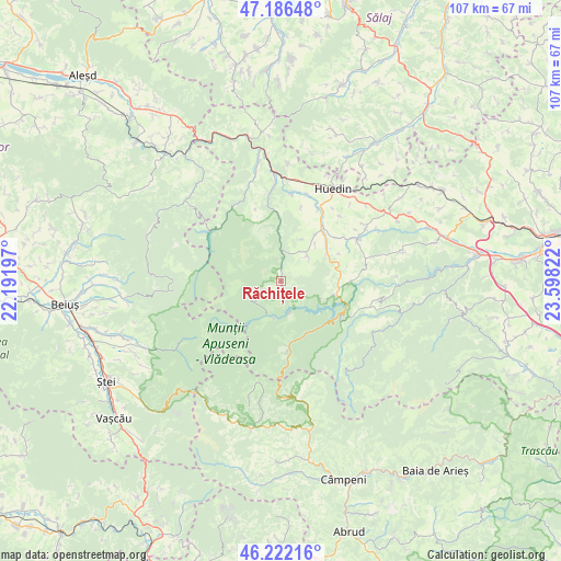
Răchițele GPS coordinates[2]
46° 42' 23.292" North, 22° 53' 42.324" East
| Map corner | latitude | longitude |
|---|---|---|
| Upper-left | 47.18648°, | 22.19197° |
| Center: | 46.70647°, | 22.89509° |
| Lower-right: | 46.22216°, | 23.59822° |
| Map W x H: | 107.2×107.2 km | = 66.6×66.6mi |
| max Lat: | 48.23793° ⇑28.2% North |
| Răchițele: | 46.70647° |
| min Lat: | ⇓71.8% South 43.65638° |
| min Long | Răchițele | max Long |
| 20.31667° | 22.89509° | 29.65403° |
| W 14.1%⇐ | ⇒85.9% E |
Elevation
Elevation of Răchițele is 837 m = 2746 ft, and this is 582.1 m = 1910 ft above average elevation for this country.
| Max E: |
1278 m = 4193 ft | 1.2% |
| Răchițele | 837 m 2746 ft | |
| Avg. | 254.9 m = 836 ft | |
Min E: |
-2 m = -7 ft | 98.8% |
See also: Romania elevation on elevation.city.
Geographical zone
Răchițele is located in North temperate zone (between Tropic of Cancer and the Arctic Circle). Distance of this North polar circle is 2207.9 km =1371.9 mi to North.| Distance of | km | miles | from Răchițele |
|---|---|---|---|
| North Pole | 4813.8 | 2991.2 | to North |
| Arctic Circle | 2207.9 | 1371.9 | to North |
| Tropic Cancer | 2587.4 | 1607.7 | to South |
| Equator | 5193.3 | 3227 | to South |


Nearby cities:
15 places around Răchițele: (largest is in red/bold)
• Bedeciu
20.6 km =12.8 mi,  61°
61°
• Beliş
12.3 km =7.6 mi,  120°
120°
• Bogdăneşti
19.9 km =12.4 mi,  114°
114°
• Călăţele
11.4 km =7.1 mi,  54°
54°
• Dealu Negru
13.1 km =8.1 mi,  87°
87°
• Huedin
21.4 km =13.3 mi,  33°
33°
• Izvoru Crişului
21 km =13 mi, 47°
• Mânăstireni
15.8 km =9.8 mi, 64°
• Măguri
18.1 km =11.2 mi, 118°
• Mărgău
7.3 km =4.5 mi, 48°
• Mărişel
19.2 km =11.9 mi, 109°
• Rogojel
10 km =6.2 mi,  345°
345°
• Râșca
16.5 km =10.3 mi,  77°
77°
• Sâncraiu
15.6 km =9.7 mi, 25°
• Săcuieu
13 km =8.1 mi,  357°
357°
Sources, notices
• [Note1] Compared only with cities in Romania existing in our database
• [Src1] Map data: © OpenStreetMap contributors (CC-BY-SA)
• [Src2] Other city data from geonames.org with taken over terms of usage.
• [Src3] Geographical zone / Annual Mean Temperature by Robert A. Rohde @ Wikipedia
