Prăjești geodata
Prăjești (Bacău) is a seat of a second-order administrative division; located in Romania in Europe/Bucharest (GMT+3) time zone. With population of 2,482 people, there are 2176 cities with bigger population in this country. Compared to other cities in Romania, 70.7% of cities are located further ↓South; 82.5% of cities are located further ←West and 56.3% of cities have higher elevation than Prăjești. Note1


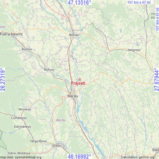
Prăjești GPS coordinates[2]
46° 39' 16.884" North, 26° 58' 34.716" East
| Map corner | latitude | longitude |
|---|---|---|
| Upper-left | 47.13516°, | 26.27319° |
| Center: | 46.65469°, | 26.97631° |
| Lower-right: | 46.16992°, | 27.67944° |
| Map W x H: | 107.3×107.3 km | = 66.7×66.7mi |
| max Lat: | 48.23793° ⇑29.3% North |
| Prăjești: | 46.65469° |
| min Lat: | ⇓70.7% South 43.65638° |
| min Long | Prăjești | max Long |
| 20.31667° | 26.97631° | 29.65403° |
| W 82.5%⇐ | ⇒17.5% E |
Elevation
Elevation of Prăjești is 181 m = 594 ft, and this is 73.9 m = 242 ft below average elevation for this country.
| Max E: |
1278 m = 4193 ft | 56.3% |
| Avg. | 254.9 m = 836 ft | |
| Prăjești | 181 m = 594 ft | |
Min E: |
-2 m = -7 ft | 43.7% |
See also: Romania elevation on elevation.city.
Geographical zone
Prăjești is located in North temperate zone (between Tropic of Cancer and the Arctic Circle). Distance of this North polar circle is 2213.7 km =1375.5 mi to North.| Distance of | km | miles | from Prăjești |
|---|---|---|---|
| North Pole | 4819.5 | 2994.7 | to North |
| Arctic Circle | 2213.7 | 1375.5 | to North |
| Tropic Cancer | 2581.6 | 1604.1 | to South |
| Equator | 5187.5 | 3223.4 | to South |


Nearby cities:
15 places around Prăjești: (largest is in red/bold)
• Bijghir
6.7 km =4.2 mi,  151°
151°
• Bogdănești
3.3 km =2.1 mi,  68°
68°
• Dămieneşti
8.8 km =5.5 mi,  3°
3°
• Hemeiuș
9.8 km =6.1 mi,  251°
251°
• Holt
8.5 km =5.3 mi,  180°
180°
• Iteşti
7.9 km =4.9 mi,  268°
268°
• Lilieci
8.5 km =5.3 mi, 250°
• Mărgineni-Munteni
8.4 km =5.2 mi,  223°
223°
• Negri
5.1 km =3.2 mi,  351°
351°
• Poiana
5.8 km =3.6 mi,  33°
33°
• Schineni
2.5 km =1.6 mi,  236°
236°
• Secuieni
9.5 km =5.9 mi,  93°
93°
• Siretu
3.9 km =2.4 mi,  298°
298°
• Săucești
4.8 km =3 mi,  213°
213°
• Traian
5 km =3.1 mi,  118°
118°
Sources, notices
• [Note1] Compared only with cities in Romania existing in our database
• [Src1] Map data: © OpenStreetMap contributors (CC-BY-SA)
• [Src2] Other city data from geonames.org with taken over terms of usage.
• [Src3] Geographical zone / Annual Mean Temperature by Robert A. Rohde @ Wikipedia
