Secuieni geodata
Secuieni (Bacău) is a seat of a second-order administrative division; located in Romania in Europe/Bucharest (GMT+3) time zone. With population of 4,375 people, there are 1012 cities with bigger population in this country. Compared to other cities in Romania, 70.5% of cities are located further ↓South; 85.1% of cities are located further ←West and 66.1% of cities have lower elevation than Secuieni. Note1


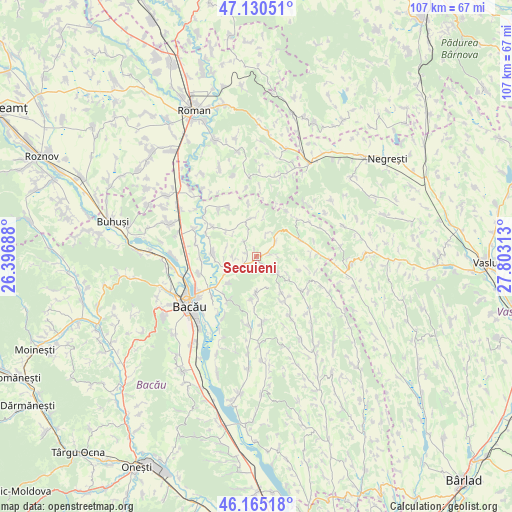
Secuieni GPS coordinates[2]
46° 39' 0" North, 27° 6' 0" East
| Map corner | latitude | longitude |
|---|---|---|
| Upper-left | 47.13051°, | 26.39688° |
| Center: | 46.65°, | 27.1° |
| Lower-right: | 46.16518°, | 27.80313° |
| Map W x H: | 107.3×107.3 km | = 66.7×66.7mi |
| max Lat: | 48.23793° ⇑29.5% North |
| Secuieni: | 46.65° |
| min Lat: | ⇓70.5% South 43.65638° |
| min Long | Secuieni | max Long |
| 20.31667° | 27.1° | 29.65403° |
| W 85.1%⇐ | ⇒14.9% E |
Elevation
Elevation of Secuieni is 297 m = 974 ft, and this is 42.1 m = 138 ft above average elevation for this country.
| Max E: |
1278 m = 4193 ft | 33.9% |
| Secuieni | 297 m 974 ft | |
| Avg. | 254.9 m = 836 ft | |
Min E: |
-2 m = -7 ft | 66.1% |
See also: Romania elevation on elevation.city.
Geographical zone
Secuieni is located in North temperate zone (between Tropic of Cancer and the Arctic Circle). Distance of this North polar circle is 2214.2 km =1375.8 mi to North.| Distance of | km | miles | from Secuieni |
|---|---|---|---|
| North Pole | 4820.1 | 2995.1 | to North |
| Arctic Circle | 2214.2 | 1375.8 | to North |
| Tropic Cancer | 2581.1 | 1603.8 | to South |
| Equator | 5187 | 3223.1 | to South |


Nearby cities:
15 places around Secuieni: (largest is in red/bold)
• Bijghir
8.2 km =5.1 mi,  229°
229°
• Bogdănești
6.6 km =4.1 mi,  285°
285°
• Botești
9.3 km =5.8 mi,  186°
186°
• Buhoci
11.2 km =7 mi,  214°
214°
• Ciuturești
5 km =3.1 mi,  21°
21°
• Fundu Tutovei
8.5 km =5.3 mi,  52°
52°
• Izvoru Berheciului
11.6 km =7.2 mi,  129°
129°
• Mâlosu
11.4 km =7.1 mi,  30°
30°
• Odobești
4.8 km =3 mi, 52°
• Plopana
9.6 km =6 mi,  67°
67°
• Poiana
8.3 km =5.2 mi,  310°
310°
• Prăjești
9.5 km =5.9 mi,  273°
273°
• Roşiori
7.5 km =4.7 mi,  350°
350°
• Tisa-Silvestri
3.1 km =1.9 mi,  82°
82°
• Traian
5.4 km =3.4 mi,  249°
249°
Sources, notices
• [Note1] Compared only with cities in Romania existing in our database
• [Src1] Map data: © OpenStreetMap contributors (CC-BY-SA)
• [Src2] Other city data from geonames.org with taken over terms of usage.
• [Src3] Geographical zone / Annual Mean Temperature by Robert A. Rohde @ Wikipedia
