Potocelu geodata
Potocelu (Dâmboviţa) is a populated place; located in Romania in Europe/Bucharest (GMT+3) time zone. With population of 886 people, there are 4675 cities with bigger population in this country. Compared to other cities in Romania, 73.3% of cities are located further ↑North; 50.6% of cities are located further ←West and 62.5% of cities have lower elevation than Potocelu. Note1


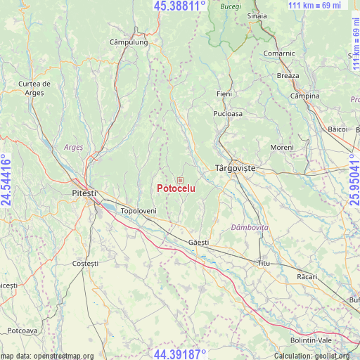
Potocelu GPS coordinates[2]
44° 53' 31.74" North, 25° 14' 50.208" East
| Map corner | latitude | longitude |
|---|---|---|
| Upper-left | 45.38811°, | 24.54416° |
| Center: | 44.89215°, | 25.24728° |
| Lower-right: | 44.39187°, | 25.95041° |
| Map W x H: | 110.8×110.8 km | = 68.8×68.8mi |
| max Lat: | 48.23793° ⇑73.3% North |
| Potocelu: | 44.89215° |
| min Lat: | ⇓26.7% South 43.65638° |
| min Long | Potocelu | max Long |
| 20.31667° | 25.24728° | 29.65403° |
| W 50.6%⇐ | ⇒49.4% E |
Elevation
Elevation of Potocelu is 277 m = 909 ft, and this is 22.1 m = 73 ft above average elevation for this country.
| Max E: |
1278 m = 4193 ft | 37.5% |
| Potocelu | 277 m 909 ft | |
| Avg. | 254.9 m = 836 ft | |
Min E: |
-2 m = -7 ft | 62.5% |
See also: Romania elevation on elevation.city.
Geographical zone
Potocelu is located in North temperate zone (between Tropic of Cancer and the Arctic Circle). Distance of this Northern Tropic circle is 2385.6 km =1482.3 mi to South.| Distance of | km | miles | from Potocelu |
|---|---|---|---|
| North Pole | 5015.5 | 3116.5 | to North |
| Arctic Circle | 2409.6 | 1497.3 | to North |
| Tropic Cancer | 2385.6 | 1482.3 | to South |
| Equator | 4991.5 | 3101.6 | to South |


Nearby cities:
15 places around Potocelu: (largest is in red/bold)
• Butoiu de Jos
6.2 km =3.9 mi,  165°
165°
• Butoiu de Sus
4.2 km =2.6 mi,  135°
135°
• Decindeni
6.6 km =4.1 mi,  70°
70°
• Dragomireşti
7.3 km =4.5 mi, 68°
• Drăgăești Ungureni
7.7 km =4.8 mi,  39°
39°
• Hulubeşti
6.6 km =4.1 mi,  189°
189°
• Ludeşti
3 km =1.9 mi,  201°
201°
• Mislea
9 km =5.6 mi,  130°
130°
• Măgura
6.5 km =4 mi, 188°
• Măneşti
8.8 km =5.5 mi,  18°
18°
• Râncăciov
8.7 km =5.4 mi,  92°
92°
• Scheiu de Jos
6 km =3.7 mi,  321°
321°
• Scheiu de Sus
8.3 km =5.2 mi,  329°
329°
• Suseni
8.2 km =5.1 mi,  276°
276°
• Telești
1.5 km =0.9 mi,  271°
271°
Sources, notices
• [Note1] Compared only with cities in Romania existing in our database
• [Src1] Map data: © OpenStreetMap contributors (CC-BY-SA)
• [Src2] Other city data from geonames.org with taken over terms of usage.
• [Src3] Geographical zone / Annual Mean Temperature by Robert A. Rohde @ Wikipedia
