Dragomireşti geodata
Dragomireşti (Dâmboviţa) is a seat of a second-order administrative division; located in Romania in Europe/Bucharest (GMT+3) time zone. With population of 8,194 people, there are 297 cities with bigger population in this country. Compared to other cities in Romania, 72.6% of cities are located further ↑North; 51.7% of cities are located further ←West and 65.9% of cities have lower elevation than Dragomireşti. Note1


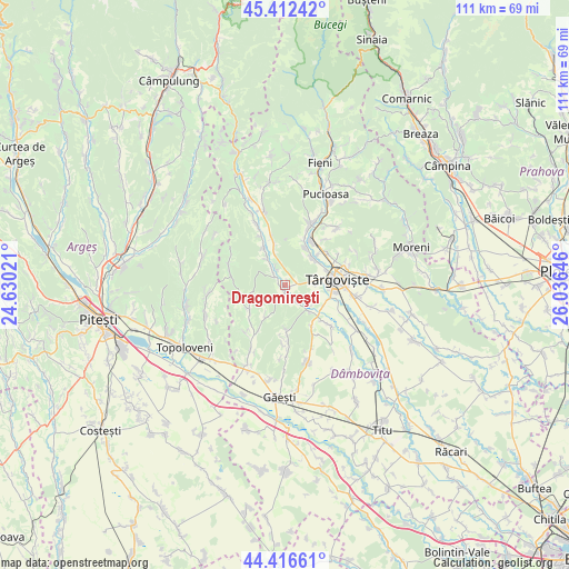
Dragomireşti GPS coordinates[2]
44° 55' 0.012" North, 25° 19' 59.988" East
| Map corner | latitude | longitude |
|---|---|---|
| Upper-left | 45.41242°, | 24.63021° |
| Center: | 44.91667°, | 25.33333° |
| Lower-right: | 44.41661°, | 26.03646° |
| Map W x H: | 110.7×110.7 km | = 68.8×68.8mi |
| max Lat: | 48.23793° ⇑72.6% North |
| Dragomireşti: | 44.91667° |
| min Lat: | ⇓27.4% South 43.65638° |
| min Long | Dragomireşti | max Long |
| 20.31667° | 25.33333° | 29.65403° |
| W 51.7%⇐ | ⇒48.3% E |
Elevation
Elevation of Dragomireşti is 295 m = 968 ft, and this is 40.1 m = 132 ft above average elevation for this country.
| Max E: |
1278 m = 4193 ft | 34.1% |
| Dragomireşti | 295 m 968 ft | |
| Avg. | 254.9 m = 836 ft | |
Min E: |
-2 m = -7 ft | 65.9% |
See also: Romania elevation on elevation.city.
Geographical zone
Dragomireşti is located in North temperate zone (between Tropic of Cancer and the Arctic Circle). Distance of this Northern Tropic circle is 2388.3 km =1484 mi to South.| Distance of | km | miles | from Dragomireşti |
|---|---|---|---|
| North Pole | 5012.8 | 3114.8 | to North |
| Arctic Circle | 2406.9 | 1495.6 | to North |
| Tropic Cancer | 2388.3 | 1484 | to South |
| Equator | 4994.3 | 3103.3 | to South |


Nearby cities:
15 places around Dragomireşti: (largest is in red/bold)
• Butoiu de Sus
6.9 km =4.3 mi,  214°
214°
• Căprioru
8.4 km =5.2 mi,  330°
330°
• Decindeni
0.7 km =0.4 mi,  229°
229°
• Drăgăești Ungureni
3.7 km =2.3 mi, 330°
• Gheboieni
8.1 km =5 mi,  345°
345°
• Mislea
8.6 km =5.3 mi,  179°
179°
• Mogoșești
6.4 km =4 mi,  126°
126°
• Măneşti
6.8 km =4.2 mi,  324°
324°
• Potocelu
7.3 km =4.5 mi,  248°
248°
• Priseaca
5.6 km =3.5 mi,  81°
81°
• Râncăciov
3.7 km =2.3 mi,  148°
148°
• Teiș
7.5 km =4.7 mi,  46°
46°
• Ungureni
6.8 km =4.2 mi,  137°
137°
• Viișoara
8.4 km =5.2 mi,  118°
118°
• Şotânga
7.9 km =4.9 mi,  19°
19°
Sources, notices
• [Note1] Compared only with cities in Romania existing in our database
• [Src1] Map data: © OpenStreetMap contributors (CC-BY-SA)
• [Src2] Other city data from geonames.org with taken over terms of usage.
• [Src3] Geographical zone / Annual Mean Temperature by Robert A. Rohde @ Wikipedia
