Potcoava Fălcoeni geodata
Potcoava Fălcoeni (Olt) is a populated place; located in Romania in Europe/Bucharest (GMT+3) time zone. With population of 1,126 people, there are 3916 cities with bigger population in this country. Compared to other cities in Romania, 85.3% of cities are located further ↑North; 58.7% of cities are located further →East and 50.8% of cities have higher elevation than Potcoava Fălcoeni. Note1


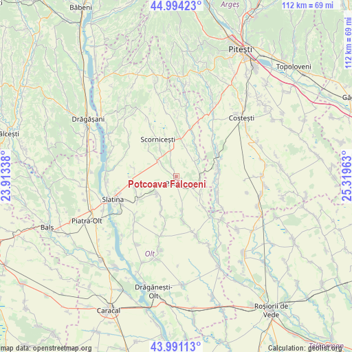
Potcoava Fălcoeni GPS coordinates[2]
44° 29' 41.424" North, 24° 36' 59.4" East
| Map corner | latitude | longitude |
|---|---|---|
| Upper-left | 44.99423°, | 23.91338° |
| Center: | 44.49484°, | 24.6165° |
| Lower-right: | 43.99113°, | 25.31963° |
| Map W x H: | 111.5×111.5 km | = 69.3×69.3mi |
| max Lat: | 48.23793° ⇑85.3% North |
| Potcoava Fălcoeni: | 44.49484° |
| min Lat: | ⇓14.7% South 43.65638° |
| min Long | Potcoava Fălco | max Long |
| 20.31667° | 24.6165° | 29.65403° |
| W 41.3%⇐ | ⇒58.7% E |
Elevation
Elevation of Potcoava Fălcoeni is 207 m = 679 ft, and this is 47.9 m = 157 ft below average elevation for this country.
| Max E: |
1278 m = 4193 ft | 50.8% |
| Avg. | 254.9 m = 836 ft | |
| Potcoava Fălcoeni | 207 m = 679 ft | |
Min E: |
-2 m = -7 ft | 49.2% |
See also: Romania elevation on elevation.city.
Geographical zone
Potcoava Fălcoeni is located in North temperate zone (between Tropic of Cancer and the Arctic Circle). Distance of this Northern Tropic circle is 2341.4 km =1454.9 mi to South.| Distance of | km | miles | from Potcoava Fălcoeni |
|---|---|---|---|
| North Pole | 5059.7 | 3144 | to North |
| Arctic Circle | 2453.8 | 1524.7 | to North |
| Tropic Cancer | 2341.4 | 1454.9 | to South |
| Equator | 4947.4 | 3074.2 | to South |


Nearby cities:
15 places around Potcoava Fălcoeni: (largest is in red/bold)
• Bircii
2.7 km =1.7 mi,  336°
336°
• Bălteni
8.4 km =5.2 mi,  232°
232°
• Bălțați
3.2 km =2 mi,  302°
302°
• Corbu
8 km =5 mi,  99°
99°
• Jitaru
7.8 km =4.8 mi,  316°
316°
• Mărgineni Slobozia
6.2 km =3.9 mi,  310°
310°
• Negreni
8.4 km =5.2 mi,  348°
348°
• Optaşi
10.2 km =6.3 mi,  15°
15°
• Potcoava
2.9 km =1.8 mi,  115°
115°
• Scorniceşti
9.6 km =6 mi,  326°
326°
• Sinești
4.9 km =3 mi,  127°
127°
• Sârbii-Măgura
10 km =6.2 mi,  52°
52°
• Ursoaia
9.1 km =5.7 mi,  136°
136°
• Valea Merilor
4.1 km =2.5 mi, 129°
• Vitănești
7.3 km =4.5 mi,  60°
60°
Sources, notices
• [Note1] Compared only with cities in Romania existing in our database
• [Src1] Map data: © OpenStreetMap contributors (CC-BY-SA)
• [Src2] Other city data from geonames.org with taken over terms of usage.
• [Src3] Geographical zone / Annual Mean Temperature by Robert A. Rohde @ Wikipedia
