Bircii geodata
Bircii (Olt) is a populated place; located in Romania in Europe/Bucharest (GMT+3) time zone. With population of 1,230 people, there are 3679 cities with bigger population in this country. Compared to other cities in Romania, 84.8% of cities are located further ↑North; 58.8% of cities are located further →East and 55.6% of cities have higher elevation than Bircii. Note1


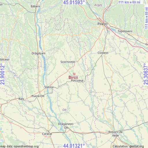
Bircii GPS coordinates[2]
44° 31' 0.228" North, 24° 36' 11.664" East
| Map corner | latitude | longitude |
|---|---|---|
| Upper-left | 45.01593°, | 23.90012° |
| Center: | 44.51673°, | 24.60324° |
| Lower-right: | 44.01321°, | 25.30637° |
| Map W x H: | 111.5×111.5 km | = 69.3×69.3mi |
| max Lat: | 48.23793° ⇑84.8% North |
| Bircii: | 44.51673° |
| min Lat: | ⇓15.2% South 43.65638° |
| min Long | Bircii | max Long |
| 20.31667° | 24.60324° | 29.65403° |
| W 41.2%⇐ | ⇒58.8% E |
Elevation
Elevation of Bircii is 184 m = 604 ft, and this is 70.9 m = 233 ft below average elevation for this country.
| Max E: |
1278 m = 4193 ft | 55.6% |
| Avg. | 254.9 m = 836 ft | |
| Bircii | 184 m = 604 ft | |
Min E: |
-2 m = -7 ft | 44.4% |
See also: Romania elevation on elevation.city.
Geographical zone
Bircii is located in North temperate zone (between Tropic of Cancer and the Arctic Circle). Distance of this Northern Tropic circle is 2343.9 km =1456.4 mi to South.| Distance of | km | miles | from Bircii |
|---|---|---|---|
| North Pole | 5057.3 | 3142.5 | to North |
| Arctic Circle | 2451.4 | 1523.2 | to North |
| Tropic Cancer | 2343.9 | 1456.4 | to South |
| Equator | 4949.8 | 3075.7 | to South |


Nearby cities:
15 places around Bircii: (largest is in red/bold)
• Bălteni
9.4 km =5.8 mi,  216°
216°
• Bălțați
1.7 km =1.1 mi,  245°
245°
• Corbu
9.7 km =6 mi,  112°
112°
• Jitaru
5.4 km =3.4 mi,  307°
307°
• Mogoșești
9 km =5.6 mi, 306°
• Mărgineni Slobozia
4 km =2.5 mi,  293°
293°
• Negreni
5.8 km =3.6 mi,  353°
353°
• Optaşi
8.3 km =5.2 mi,  26°
26°
• Potcoava
5.2 km =3.2 mi,  135°
135°
• Potcoava Fălcoeni
2.7 km =1.7 mi,  156°
156°
• Scorniceşti
7 km =4.3 mi,  322°
322°
• Sinești
7.4 km =4.6 mi, 137°
• Sârbii-Măgura
9.7 km =6 mi,  67°
67°
• Valea Merilor
6.5 km =4 mi, 140°
• Vitănești
7.4 km =4.6 mi,  80°
80°
Sources, notices
• [Note1] Compared only with cities in Romania existing in our database
• [Src1] Map data: © OpenStreetMap contributors (CC-BY-SA)
• [Src2] Other city data from geonames.org with taken over terms of usage.
• [Src3] Geographical zone / Annual Mean Temperature by Robert A. Rohde @ Wikipedia
