Scorniceşti geodata
Scorniceşti (Olt) is a seat of a second-order administrative division; located in Romania in Europe/Bucharest (GMT+3) time zone. With population of 12,456 people, there are 155 cities with bigger population in this country. Compared to other cities in Romania, 83.8% of cities are located further ↑North; 59.6% of cities are located further →East and 51.5% of cities have higher elevation than Scorniceşti. Note1


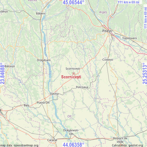
Scorniceşti GPS coordinates[2]
44° 34' 0.012" North, 24° 33' 0" East
| Map corner | latitude | longitude |
|---|---|---|
| Upper-left | 45.06544°, | 23.84688° |
| Center: | 44.56667°, | 24.55° |
| Lower-right: | 44.06358°, | 25.25313° |
| Map W x H: | 111.4×111.4 km | = 69.2×69.2mi |
| max Lat: | 48.23793° ⇑83.8% North |
| Scorniceşti: | 44.56667° |
| min Lat: | ⇓16.2% South 43.65638° |
| min Long | Scorniceşti | max Long |
| 20.31667° | 24.55° | 29.65403° |
| W 40.4%⇐ | ⇒59.6% E |
Elevation
Elevation of Scorniceşti is 204 m = 669 ft, and this is 50.9 m = 167 ft below average elevation for this country.
| Max E: |
1278 m = 4193 ft | 51.5% |
| Avg. | 254.9 m = 836 ft | |
| Scorniceşti | 204 m = 669 ft | |
Min E: |
-2 m = -7 ft | 48.5% |
See also: Romania elevation on elevation.city.
Geographical zone
Scorniceşti is located in North temperate zone (between Tropic of Cancer and the Arctic Circle). Distance of this Northern Tropic circle is 2349.4 km =1459.8 mi to South.| Distance of | km | miles | from Scorniceşti |
|---|---|---|---|
| North Pole | 5051.7 | 3139 | to North |
| Arctic Circle | 2445.8 | 1519.7 | to North |
| Tropic Cancer | 2349.4 | 1459.8 | to South |
| Equator | 4955.3 | 3079.1 | to South |


Nearby cities:
15 places around Scorniceşti: (largest is in red/bold)
• Bircii
7 km =4.3 mi,  142°
142°
• Bălțați
6.8 km =4.2 mi,  157°
157°
• Constantinești
4.9 km =3 mi,  308°
308°
• Jitaru
2.3 km =1.4 mi,  182°
182°
• Mogoșești
3.1 km =1.9 mi,  265°
265°
• Mărgineni Slobozia
4 km =2.5 mi,  172°
172°
• Negreni
3.6 km =2.2 mi,  86°
86°
• Oporelu
11.2 km =7 mi,  289°
289°
• Optaşi
8.1 km =5 mi,  76°
76°
• Poboru
11.8 km =7.3 mi,  340°
340°
• Potcoava
12.2 km =7.6 mi, 139°
• Potcoava Fălcoeni
9.6 km =6 mi,  146°
146°
• Priseaca
9.7 km =6 mi,  234°
234°
• Tătuleşti
9.9 km =6.2 mi,  41°
41°
• Vitănești
12.4 km =7.7 mi,  110°
110°
Sources, notices
• [Note1] Compared only with cities in Romania existing in our database
• [Src1] Map data: © OpenStreetMap contributors (CC-BY-SA)
• [Src2] Other city data from geonames.org with taken over terms of usage.
• [Src3] Geographical zone / Annual Mean Temperature by Robert A. Rohde @ Wikipedia
