Podu Broșteni geodata
Podu Broșteni (Arges) is a populated place; located in Romania in Europe/Bucharest (GMT+3) time zone. With population of 568 people, there are 6441 cities with bigger population in this country. Compared to other cities in Romania, 78.6% of cities are located further ↑North; 54.6% of cities are located further →East and 60.4% of cities have lower elevation than Podu Broșteni. Note1


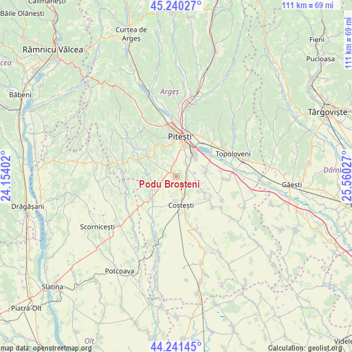
Podu Broșteni GPS coordinates[2]
44° 44' 34.872" North, 24° 51' 25.704" East
| Map corner | latitude | longitude |
|---|---|---|
| Upper-left | 45.24027°, | 24.15402° |
| Center: | 44.74302°, | 24.85714° |
| Lower-right: | 44.24145°, | 25.56027° |
| Map W x H: | 111.1×111.1 km | = 69×69mi |
| max Lat: | 48.23793° ⇑78.6% North |
| Podu Broșteni: | 44.74302° |
| min Lat: | ⇓21.4% South 43.65638° |
| min Long | Podu Broșteni | max Long |
| 20.31667° | 24.85714° | 29.65403° |
| W 45.4%⇐ | ⇒54.6% E |
Elevation
Elevation of Podu Broșteni is 265 m = 869 ft, and this is 10.1 m = 33 ft above average elevation for this country.
| Max E: |
1278 m = 4193 ft | 39.6% |
| Podu Broșteni | 265 m 869 ft | |
| Avg. | 254.9 m = 836 ft | |
Min E: |
-2 m = -7 ft | 60.4% |
See also: Romania elevation on elevation.city.
Geographical zone
Podu Broșteni is located in North temperate zone (between Tropic of Cancer and the Arctic Circle). Distance of this Northern Tropic circle is 2369 km =1472 mi to South.| Distance of | km | miles | from Podu Broșteni |
|---|---|---|---|
| North Pole | 5032.1 | 3126.8 | to North |
| Arctic Circle | 2426.2 | 1507.6 | to North |
| Tropic Cancer | 2369 | 1472 | to South |
| Equator | 4975 | 3091.3 | to South |


Nearby cities:
15 places around Podu Broșteni: (largest is in red/bold)
• Albota
4.5 km =2.8 mi,  352°
352°
• Albota de Jos
3.2 km =2 mi,  324°
324°
• Bradu
5.6 km =3.5 mi,  37°
37°
• Broșteni
3 km =1.9 mi,  164°
164°
• Bănărești
7.7 km =4.8 mi,  259°
259°
• Cerbu
3.3 km =2.1 mi,  300°
300°
• Costeşti
8.7 km =5.4 mi,  166°
166°
• Geamăna
9 km =5.6 mi,  17°
17°
• Hințești
7.9 km =4.9 mi, 353°
• Mareș
6.6 km =4.1 mi,  306°
306°
• Mârţeşti
9 km =5.6 mi,  250°
250°
• Oarja
9.6 km =6 mi,  78°
78°
• Oarja Sat
9.3 km =5.8 mi, 75°
• Pârvu Roșu
3.6 km =2.2 mi,  107°
107°
• Suseni
7.9 km =4.9 mi, 111°
Sources, notices
• [Note1] Compared only with cities in Romania existing in our database
• [Src1] Map data: © OpenStreetMap contributors (CC-BY-SA)
• [Src2] Other city data from geonames.org with taken over terms of usage.
• [Src3] Geographical zone / Annual Mean Temperature by Robert A. Rohde @ Wikipedia
