Costeşti geodata
Costeşti (Arges) is a seat of a second-order administrative division; located in Romania in Europe/Bucharest (GMT+3) time zone. With population of 10,654 people, there are 193 cities with bigger population in this country. Compared to other cities in Romania, 81.1% of cities are located further ↑North; 54.4% of cities are located further →East and 53.5% of cities have lower elevation than Costeşti. Note1


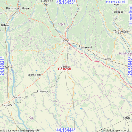
Costeşti GPS coordinates[2]
44° 40' 0.012" North, 24° 52' 59.988" East
| Map corner | latitude | longitude |
|---|---|---|
| Upper-left | 45.16458°, | 24.18021° |
| Center: | 44.66667°, | 24.88333° |
| Lower-right: | 44.16444°, | 25.58646° |
| Map W x H: | 111.2×111.2 km | = 69.1×69.1mi |
| max Lat: | 48.23793° ⇑81.1% North |
| Costeşti: | 44.66667° |
| min Lat: | ⇓18.9% South 43.65638° |
| min Long | Costeşti | max Long |
| 20.31667° | 24.88333° | 29.65403° |
| W 45.6%⇐ | ⇒54.4% E |
Elevation
Elevation of Costeşti is 231 m = 758 ft, and this is 23.9 m = 78 ft below average elevation for this country.
| Max E: |
1278 m = 4193 ft | 46.5% |
| Avg. | 254.9 m = 836 ft | |
| Costeşti | 231 m = 758 ft | |
Min E: |
-2 m = -7 ft | 53.5% |
See also: Romania elevation on elevation.city.
Geographical zone
Costeşti is located in North temperate zone (between Tropic of Cancer and the Arctic Circle). Distance of this Northern Tropic circle is 2360.5 km =1466.7 mi to South.| Distance of | km | miles | from Costeşti |
|---|---|---|---|
| North Pole | 5040.6 | 3132.1 | to North |
| Arctic Circle | 2434.7 | 1512.9 | to North |
| Tropic Cancer | 2360.5 | 1466.7 | to South |
| Equator | 4966.5 | 3086 | to South |


Nearby cities:
15 places around Costeşti: (largest is in red/bold)
• Albota de Jos
11.8 km =7.3 mi,  340°
340°
• Broșteni
5.7 km =3.5 mi,  347°
347°
• Buzoeşti
9.6 km =6 mi,  164°
164°
• Cerbu
11.3 km =7 mi,  334°
334°
• Cornățel
11.2 km =7 mi,  149°
149°
• Gliganu de Sus
9.5 km =5.9 mi,  96°
96°
• Ionești
6.2 km =3.9 mi,  166°
166°
• Lunca Corbului
10.1 km =6.3 mi,  280°
280°
• Podu Broșteni
8.7 km =5.4 mi, 346°
• Pârvu Roșu
7.5 km =4.7 mi,  10°
10°
• Rociu
11.9 km =7.4 mi,  90°
90°
• Suseni
7.7 km =4.8 mi,  43°
43°
• Vulpești
9 km =5.6 mi, 148°
• Șerboeni
3.3 km =2.1 mi, 165°
• Șerbănești
8.8 km =5.5 mi,  79°
79°
Sources, notices
• [Note1] Compared only with cities in Romania existing in our database
• [Src1] Map data: © OpenStreetMap contributors (CC-BY-SA)
• [Src2] Other city data from geonames.org with taken over terms of usage.
• [Src3] Geographical zone / Annual Mean Temperature by Robert A. Rohde @ Wikipedia
