Oarja Sat geodata
Oarja Sat (Arges) is a populated place; located in Romania in Europe/Bucharest (GMT+3) time zone. With population of 2,851 people, there are 1875 cities with bigger population in this country. Compared to other cities in Romania, 78% of cities are located further ↑North; 53% of cities are located further →East and 61.2% of cities have lower elevation than Oarja Sat. Note1


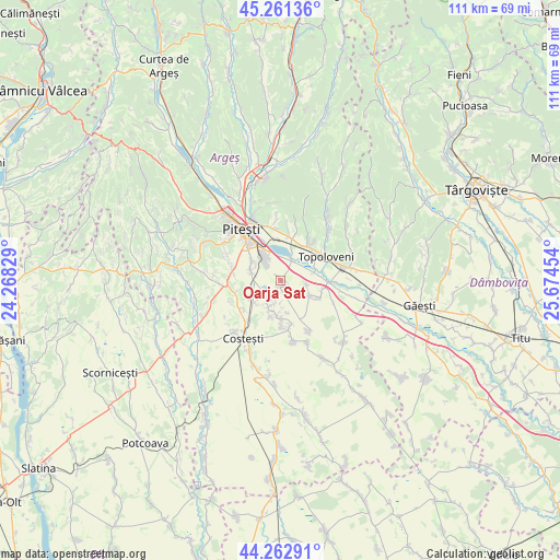
Oarja Sat GPS coordinates[2]
44° 45' 51.444" North, 24° 58' 17.076" East
| Map corner | latitude | longitude |
|---|---|---|
| Upper-left | 45.26136°, | 24.26829° |
| Center: | 44.76429°, | 24.97141° |
| Lower-right: | 44.26291°, | 25.67454° |
| Map W x H: | 111×111 km | = 69×69mi |
| max Lat: | 48.23793° ⇑78% North |
| Oarja Sat: | 44.76429° |
| min Lat: | ⇓22% South 43.65638° |
| min Long | Oarja Sat | max Long |
| 20.31667° | 24.97141° | 29.65403° |
| W 47%⇐ | ⇒53% E |
Elevation
Elevation of Oarja Sat is 270 m = 886 ft, and this is 15.1 m = 50 ft above average elevation for this country.
| Max E: |
1278 m = 4193 ft | 38.8% |
| Oarja Sat | 270 m 886 ft | |
| Avg. | 254.9 m = 836 ft | |
Min E: |
-2 m = -7 ft | 61.2% |
See also: Romania elevation on elevation.city.
Geographical zone
Oarja Sat is located in North temperate zone (between Tropic of Cancer and the Arctic Circle). Distance of this Northern Tropic circle is 2371.4 km =1473.5 mi to South.| Distance of | km | miles | from Oarja Sat |
|---|---|---|---|
| North Pole | 5029.7 | 3125.3 | to North |
| Arctic Circle | 2423.9 | 1506.1 | to North |
| Tropic Cancer | 2371.4 | 1473.5 | to South |
| Equator | 4977.3 | 3092.7 | to South |


Nearby cities:
15 places around Oarja Sat: (largest is in red/bold)
• Bradu
6 km =3.7 mi,  290°
290°
• Cireșu
5.2 km =3.2 mi,  94°
94°
• Călineşti
8.5 km =5.3 mi,  46°
46°
• Căteasca
8.8 km =5.5 mi, 88°
• Geamăna
8.9 km =5.5 mi,  314°
314°
• Golești
8.4 km =5.2 mi,  356°
356°
• Gruiu
8.4 km =5.2 mi,  112°
112°
• Oarja
0.6 km =0.4 mi,  139°
139°
• Podu Broșteni
9.3 km =5.8 mi,  255°
255°
• Popeşti
7.5 km =4.7 mi, 87°
• Pârvu Roșu
6.6 km =4.1 mi,  238°
238°
• Siliștea
6.4 km =4 mi,  115°
115°
• Suseni
5.6 km =3.5 mi,  197°
197°
• Udeni-Zăvoi
7.5 km =4.7 mi,  16°
16°
• Șerbănești
9.4 km =5.8 mi,  169°
169°
Sources, notices
• [Note1] Compared only with cities in Romania existing in our database
• [Src1] Map data: © OpenStreetMap contributors (CC-BY-SA)
• [Src2] Other city data from geonames.org with taken over terms of usage.
• [Src3] Geographical zone / Annual Mean Temperature by Robert A. Rohde @ Wikipedia
