Fântânele geodata
Fântânele (Gorj) is a populated place; located in Romania in Europe/Bucharest (GMT+3) time zone. With population of 931 people, there are 4511 cities with bigger population in this country. Compared to other cities in Romania, 77.5% of cities are located further ↑North; 79.9% of cities are located further →East and 65.7% of cities have higher elevation than Fântânele. Note1


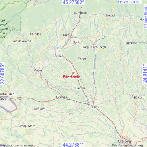
Fântânele GPS coordinates[2]
44° 46' 41.052" North, 23° 18' 39.492" East
| Map corner | latitude | longitude |
|---|---|---|
| Upper-left | 45.27502°, | 22.60785° |
| Center: | 44.77807°, | 23.31097° |
| Lower-right: | 44.27681°, | 24.0141° |
| Map W x H: | 111×111 km | = 69×69mi |
| max Lat: | 48.23793° ⇑77.5% North |
| Fântânele: | 44.77807° |
| min Lat: | ⇓22.5% South 43.65638° |
| min Long | Fântânele | max Long |
| 20.31667° | 23.31097° | 29.65403° |
| W 20.1%⇐ | ⇒79.9% E |
Elevation
Elevation of Fântânele is 144 m = 472 ft, and this is 110.9 m = 364 ft below average elevation for this country.
| Max E: |
1278 m = 4193 ft | 65.7% |
| Avg. | 254.9 m = 836 ft | |
| Fântânele | 144 m = 472 ft | |
Min E: |
-2 m = -7 ft | 34.3% |
See also: Romania elevation on elevation.city.
Geographical zone
Fântânele is located in North temperate zone (between Tropic of Cancer and the Arctic Circle). Distance of this Northern Tropic circle is 2372.9 km =1474.5 mi to South.| Distance of | km | miles | from Fântânele |
|---|---|---|---|
| North Pole | 5028.2 | 3124.4 | to North |
| Arctic Circle | 2422.3 | 1505.1 | to North |
| Tropic Cancer | 2372.9 | 1474.5 | to South |
| Equator | 4978.9 | 3093.7 | to South |


Nearby cities:
15 places around Fântânele: (largest is in red/bold)
• Artanu
7.1 km =4.4 mi,  278°
278°
• Bolboşi
8.1 km =5 mi,  247°
247°
• Cocoreni
5.5 km =3.4 mi,  2°
2°
• Hotăroasa
5.5 km =3.4 mi,  335°
335°
• Murgești
8.6 km =5.3 mi,  150°
150°
• Ohaba Jiu
8.1 km =5 mi,  218°
218°
• Olari
3.7 km =2.3 mi,  27°
27°
• Peșteana Jiu
7.7 km =4.8 mi,  355°
355°
• Peșteana de Jos
7 km =4.3 mi,  332°
332°
• Piscuri
6.5 km =4 mi,  91°
91°
• Plopşoru
3.1 km =1.9 mi,  79°
79°
• Sărdănești
4 km =2.5 mi,  101°
101°
• Urdari
2.6 km =1.6 mi, 340°
• Valea Viei
4.5 km =2.8 mi,  155°
155°
• Văleni
7.3 km =4.5 mi,  124°
124°
Sources, notices
• [Note1] Compared only with cities in Romania existing in our database
• [Src1] Map data: © OpenStreetMap contributors (CC-BY-SA)
• [Src2] Other city data from geonames.org with taken over terms of usage.
• [Src3] Geographical zone / Annual Mean Temperature by Robert A. Rohde @ Wikipedia
