Plevna geodata
Plevna (Călăraşi) is a populated place; located in Romania in Europe/Bucharest (GMT+3) time zone. With population of 801 people, there are 5041 cities with bigger population in this country. Compared to other cities in Romania, 89.3% of cities are located further ↑North; 82.9% of cities are located further ←West and 93.7% of cities have higher elevation than Plevna. Note1


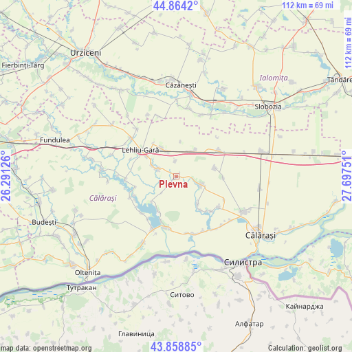
Plevna GPS coordinates[2]
44° 21' 49.248" North, 26° 59' 39.768" East
| Map corner | latitude | longitude |
|---|---|---|
| Upper-left | 44.8642°, | 26.29126° |
| Center: | 44.36368°, | 26.99438° |
| Lower-right: | 43.85885°, | 27.69751° |
| Map W x H: | 111.8×111.8 km | = 69.5×69.5mi |
| max Lat: | 48.23793° ⇑89.3% North |
| Plevna: | 44.36368° |
| min Lat: | ⇓10.7% South 43.65638° |
| min Long | Plevna | max Long |
| 20.31667° | 26.99438° | 29.65403° |
| W 82.9%⇐ | ⇒17.1% E |
Elevation
Elevation of Plevna is 40 m = 131 ft, and this is 214.9 m = 705 ft below average elevation for this country.
| Max E: |
1278 m = 4193 ft | 93.7% |
| Avg. | 254.9 m = 836 ft | |
| Plevna | 40 m = 131 ft | |
Min E: |
-2 m = -7 ft | 6.3% |
See also: Romania elevation on elevation.city.
Geographical zone
Plevna is located in North temperate zone (between Tropic of Cancer and the Arctic Circle). Distance of this Northern Tropic circle is 2326.9 km =1445.9 mi to South.| Distance of | km | miles | from Plevna |
|---|---|---|---|
| North Pole | 5074.3 | 3153 | to North |
| Arctic Circle | 2468.4 | 1533.8 | to North |
| Tropic Cancer | 2326.9 | 1445.9 | to South |
| Equator | 4932.8 | 3065.1 | to South |


Nearby cities:
15 places around Plevna: (largest is in red/bold)
• Alexandru Odobescu
12.9 km =8 mi,  146°
146°
• Dor Mărunt
11.4 km =7.1 mi,  327°
327°
• Dâlga
10.7 km =6.6 mi,  35°
35°
• Dâlga-Gară
8.9 km =5.5 mi,  29°
29°
• Făurei
10.9 km =6.8 mi,  224°
224°
• Lehliu-Gară
13.8 km =8.6 mi,  304°
304°
• Lupşanu
7.8 km =4.8 mi,  286°
286°
• Mihai Viteazu
6.5 km =4 mi,  104°
104°
• Nicolae Bălcescu
10.9 km =6.8 mi,  142°
142°
• Nucetu
8.2 km =5.1 mi, 294°
• Radu Vodă
6 km =3.7 mi, 294°
• Răzvani
11 km =6.8 mi,  305°
305°
• Ulmu
12.4 km =7.7 mi,  209°
209°
• Vlad Ţepeş
7.2 km =4.5 mi, 102°
• Vâlcelele
12.7 km =7.9 mi,  77°
77°
Sources, notices
• [Note1] Compared only with cities in Romania existing in our database
• [Src1] Map data: © OpenStreetMap contributors (CC-BY-SA)
• [Src2] Other city data from geonames.org with taken over terms of usage.
• [Src3] Geographical zone / Annual Mean Temperature by Robert A. Rohde @ Wikipedia
