Lehliu-Gară geodata
Lehliu-Gară (Călăraşi) is a populated place; located in Romania in Europe/Bucharest (GMT+3) time zone. With population of 6,538 people, there are 463 cities with bigger population in this country. Compared to other cities in Romania, 87.3% of cities are located further ↑North; 79.7% of cities are located further ←West and 91.4% of cities have higher elevation than Lehliu-Gară. Note1


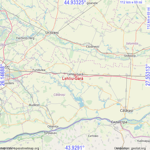
Lehliu-Gară GPS coordinates[2]
44° 25' 59.988" North, 26° 51' 0" East
| Map corner | latitude | longitude |
|---|---|---|
| Upper-left | 44.93325°, | 26.14688° |
| Center: | 44.43333°, | 26.85° |
| Lower-right: | 43.9291°, | 27.55313° |
| Map W x H: | 111.7×111.7 km | = 69.4×69.4mi |
| max Lat: | 48.23793° ⇑87.3% North |
| Lehliu-Gară: | 44.43333° |
| min Lat: | ⇓12.7% South 43.65638° |
| min Long | Lehliu-Gară | max Long |
| 20.31667° | 26.85° | 29.65403° |
| W 79.7%⇐ | ⇒20.3% E |
Elevation
Elevation of Lehliu-Gară is 51 m = 167 ft, and this is 203.9 m = 669 ft below average elevation for this country.
| Max E: |
1278 m = 4193 ft | 91.4% |
| Avg. | 254.9 m = 836 ft | |
| Lehliu-Gară | 51 m = 167 ft | |
Min E: |
-2 m = -7 ft | 8.6% |
See also: Romania elevation on elevation.city.
Geographical zone
Lehliu-Gară is located in North temperate zone (between Tropic of Cancer and the Arctic Circle). Distance of this Northern Tropic circle is 2334.6 km =1450.7 mi to South.| Distance of | km | miles | from Lehliu-Gară |
|---|---|---|---|
| North Pole | 5066.5 | 3148.2 | to North |
| Arctic Circle | 2460.7 | 1529 | to North |
| Tropic Cancer | 2334.6 | 1450.7 | to South |
| Equator | 4940.5 | 3069.9 | to South |


Nearby cities:
15 places around Lehliu-Gară: (largest is in red/bold)
• Buzoeni
3.7 km =2.3 mi,  234°
234°
• Dor Mărunt
5.6 km =3.5 mi,  70°
70°
• Horia
12.2 km =7.6 mi,  342°
342°
• Lehliu
4.6 km =2.9 mi,  324°
324°
• Lupşanu
6.8 km =4.2 mi,  144°
144°
• Nicolae Bălcescu
6.9 km =4.3 mi,  285°
285°
• Nucetu
5.9 km =3.7 mi, 136°
• Radu Vodă
8 km =5 mi,  131°
131°
• Rași
12.8 km =8 mi,  27°
27°
• Răzvani
2.8 km =1.7 mi,  118°
118°
• Siliștea
10.5 km =6.5 mi,  223°
223°
• Sălcioara
11.4 km =7.1 mi,  13°
13°
• Săpunari
7.6 km =4.7 mi,  352°
352°
• Valea Argovei
10.7 km =6.6 mi,  209°
209°
• Ștefănești
12.4 km =7.7 mi,  314°
314°
Sources, notices
• [Note1] Compared only with cities in Romania existing in our database
• [Src1] Map data: © OpenStreetMap contributors (CC-BY-SA)
• [Src2] Other city data from geonames.org with taken over terms of usage.
• [Src3] Geographical zone / Annual Mean Temperature by Robert A. Rohde @ Wikipedia
