Plăviceni geodata
Plăviceni (Olt) is a populated place; located in Romania in Europe/Bucharest (GMT+3) time zone. With population of 839 people, there are 4887 cities with bigger population in this country. Compared to other cities in Romania, 97.3% of cities are located further ↑North; 59.1% of cities are located further →East and 90.2% of cities have higher elevation than Plăviceni. Note1


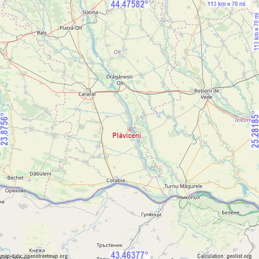
Plăviceni GPS coordinates[2]
43° 58' 19.02" North, 24° 34' 43.392" East
| Map corner | latitude | longitude |
|---|---|---|
| Upper-left | 44.47582°, | 23.8756° |
| Center: | 43.97195°, | 24.57872° |
| Lower-right: | 43.46377°, | 25.28185° |
| Map W x H: | 112.5×112.5 km | = 69.9×69.9mi |
| max Lat: | 48.23793° ⇑97.3% North |
| Plăviceni: | 43.97195° |
| min Lat: | ⇓2.7% South 43.65638° |
| min Long | Plăviceni | max Long |
| 20.31667° | 24.57872° | 29.65403° |
| W 40.9%⇐ | ⇒59.1% E |
Elevation
Elevation of Plăviceni is 57 m = 187 ft, and this is 197.9 m = 649 ft below average elevation for this country.
| Max E: |
1278 m = 4193 ft | 90.2% |
| Avg. | 254.9 m = 836 ft | |
| Plăviceni | 57 m = 187 ft | |
Min E: |
-2 m = -7 ft | 9.8% |
See also: Romania elevation on elevation.city.
Geographical zone
Plăviceni is located in North temperate zone (between Tropic of Cancer and the Arctic Circle). Distance of this Northern Tropic circle is 2283.3 km =1418.8 mi to South.| Distance of | km | miles | from Plăviceni |
|---|---|---|---|
| North Pole | 5117.8 | 3180.1 | to North |
| Arctic Circle | 2512 | 1560.9 | to North |
| Tropic Cancer | 2283.3 | 1418.8 | to South |
| Equator | 4889.2 | 3038 | to South |


Nearby cities:
15 places around Plăviceni: (largest is in red/bold)
• Beciu
7.8 km =4.8 mi,  62°
62°
• Brâncoveanca
9.8 km =6.1 mi,  110°
110°
• Bârseștii de Sus
9.8 km =6.1 mi,  45°
45°
• Băbiciu
6.9 km =4.3 mi,  351°
351°
• Cilieni
8.6 km =5.3 mi,  159°
159°
• Dudu
8 km =5 mi,  84°
84°
• Frunzaru
7.9 km =4.9 mi,  7°
7°
• Jieni
2.6 km =1.6 mi,  153°
153°
• Plopii Slăviţeştí
8.4 km =5.2 mi,  94°
94°
• Potlogeni
11.1 km =6.9 mi, 157°
• Rusăneşti
4.6 km =2.9 mi, 158°
• Scărişoara
3.3 km =2.1 mi,  342°
342°
• Slobozia-Mândra
11.5 km =7.1 mi,  122°
122°
• Smârdan
8.6 km =5.3 mi, 53°
• Traian
11.4 km =7.1 mi,  295°
295°
Sources, notices
• [Note1] Compared only with cities in Romania existing in our database
• [Src1] Map data: © OpenStreetMap contributors (CC-BY-SA)
• [Src2] Other city data from geonames.org with taken over terms of usage.
• [Src3] Geographical zone / Annual Mean Temperature by Robert A. Rohde @ Wikipedia
