Beciu geodata
Beciu (Teleorman) is a seat of a second-order administrative division; located in Romania in Europe/Bucharest (GMT+3) time zone. With population of 1,430 people, there are 3284 cities with bigger population in this country. Compared to other cities in Romania, 96.9% of cities are located further ↑North; 57.8% of cities are located further →East and 85.7% of cities have higher elevation than Beciu. Note1


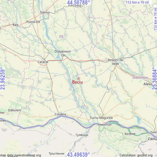
Beciu GPS coordinates[2]
44° 0' 15.444" North, 24° 39' 56.556" East
| Map corner | latitude | longitude |
|---|---|---|
| Upper-left | 44.50788°, | 23.96259° |
| Center: | 44.00429°, | 24.66571° |
| Lower-right: | 43.49639°, | 25.36884° |
| Map W x H: | 112.5×112.5 km | = 69.9×69.9mi |
| max Lat: | 48.23793° ⇑96.9% North |
| Beciu: | 44.00429° |
| min Lat: | ⇓3.1% South 43.65638° |
| min Long | Beciu | max Long |
| 20.31667° | 24.66571° | 29.65403° |
| W 42.2%⇐ | ⇒57.8% E |
Elevation
Elevation of Beciu is 76 m = 249 ft, and this is 178.9 m = 587 ft below average elevation for this country.
| Max E: |
1278 m = 4193 ft | 85.7% |
| Avg. | 254.9 m = 836 ft | |
| Beciu | 76 m = 249 ft | |
Min E: |
-2 m = -7 ft | 14.3% |
See also: Romania elevation on elevation.city.
Geographical zone
Beciu is located in North temperate zone (between Tropic of Cancer and the Arctic Circle). Distance of this Northern Tropic circle is 2286.9 km =1421 mi to South.| Distance of | km | miles | from Beciu |
|---|---|---|---|
| North Pole | 5114.2 | 3177.8 | to North |
| Arctic Circle | 2508.4 | 1558.6 | to North |
| Tropic Cancer | 2286.9 | 1421 | to South |
| Equator | 4892.8 | 3040.2 | to South |


Nearby cities:
15 places around Beciu: (largest is in red/bold)
• Brâncoveanca
7.4 km =4.6 mi,  162°
162°
• Bârseștii de Sus
3.2 km =2 mi,  1°
1°
• Băbiciu
8.6 km =5.3 mi,  292°
292°
• Crângeni
9.9 km =6.2 mi,  71°
71°
• Călinești
8.3 km =5.2 mi,  12°
12°
• Dudu
3 km =1.9 mi, 160°
• Frunzaru
7.3 km =4.5 mi,  305°
305°
• Jieni
8.3 km =5.2 mi,  224°
224°
• Plopii Slăviţeştí
4.4 km =2.7 mi, 161°
• Plăviceni
7.8 km =4.8 mi,  242°
242°
• Rusăneşti
9.5 km =5.9 mi,  213°
213°
• Scărişoara
7.9 km =4.9 mi,  266°
266°
• Slobozia-Mândra
10.1 km =6.3 mi, 164°
• Smârdan
1.5 km =0.9 mi,  358°
358°
• Sprâncenata
9.2 km =5.7 mi,  343°
343°
Sources, notices
• [Note1] Compared only with cities in Romania existing in our database
• [Src1] Map data: © OpenStreetMap contributors (CC-BY-SA)
• [Src2] Other city data from geonames.org with taken over terms of usage.
• [Src3] Geographical zone / Annual Mean Temperature by Robert A. Rohde @ Wikipedia
