Pericei geodata
Pericei (Sălaj) is a seat of a second-order administrative division; located in Romania in Europe/Bucharest (GMT+3) time zone. With population of 2,785 people, there are 1926 cities with bigger population in this country. Compared to other cities in Romania, 84.9% of cities are located further ↓South; 86.2% of cities are located further →East and 51.8% of cities have lower elevation than Pericei. Note1


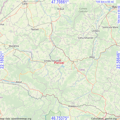
Pericei GPS coordinates[2]
47° 13' 59.988" North, 22° 52' 59.988" East
| Map corner | latitude | longitude |
|---|---|---|
| Upper-left | 47.70861°, | 22.18021° |
| Center: | 47.23333°, | 22.88333° |
| Lower-right: | 46.75375°, | 23.58646° |
| Map W x H: | 106.2×106.2 km | = 66×66mi |
| max Lat: | 48.23793° ⇑15.1% North |
| Pericei: | 47.23333° |
| min Lat: | ⇓84.9% South 43.65638° |
| min Long | Pericei | max Long |
| 20.31667° | 22.88333° | 29.65403° |
| W 13.8%⇐ | ⇒86.2% E |
Elevation
Elevation of Pericei is 221 m = 725 ft, and this is 33.9 m = 111 ft below average elevation for this country.
| Max E: |
1278 m = 4193 ft | 48.2% |
| Avg. | 254.9 m = 836 ft | |
| Pericei | 221 m = 725 ft | |
Min E: |
-2 m = -7 ft | 51.8% |
See also: Romania elevation on elevation.city.
Geographical zone
Pericei is located in North temperate zone (between Tropic of Cancer and the Arctic Circle). Distance of this North polar circle is 2149.3 km =1335.5 mi to North.| Distance of | km | miles | from Pericei |
|---|---|---|---|
| North Pole | 4755.2 | 2954.7 | to North |
| Arctic Circle | 2149.3 | 1335.5 | to North |
| Tropic Cancer | 2645.9 | 1644.1 | to South |
| Equator | 5251.9 | 3263.4 | to South |


Nearby cities:
15 places around Pericei: (largest is in red/bold)
• Badon
7.4 km =4.6 mi,  75°
75°
• Bocşa
7.1 km =4.4 mi,  18°
18°
• Bădăcin
3.3 km =2.1 mi,  319°
319°
• Cehei
8.6 km =5.3 mi,  287°
287°
• Crasna
7.5 km =4.7 mi,  170°
170°
• Giurtelecu Șimleului
9.7 km =6 mi, 316°
• Guruslău
9 km =5.6 mi,  56°
56°
• Hereclean
10.2 km =6.3 mi, 79°
• Huseni
8.2 km =5.1 mi,  227°
227°
• Ilișua
7.9 km =4.9 mi,  335°
335°
• Panic
8.9 km =5.5 mi,  110°
110°
• Recea
6.3 km =3.9 mi,  131°
131°
• Sălăjeni
9.8 km =6.1 mi,  9°
9°
• Vârşolţ
5.3 km =3.3 mi, 134°
• Şimleu Silvaniei
6.3 km =3.9 mi,  270°
270°
Sources, notices
• [Note1] Compared only with cities in Romania existing in our database
• [Src1] Map data: © OpenStreetMap contributors (CC-BY-SA)
• [Src2] Other city data from geonames.org with taken over terms of usage.
• [Src3] Geographical zone / Annual Mean Temperature by Robert A. Rohde @ Wikipedia
