Orvișele geodata
Orvișele (Bihor) is a populated place; located in Romania in Europe/Bucharest (GMT+3) time zone. With population of 678 people, there are 5700 cities with bigger population in this country. Compared to other cities in Romania, 82.1% of cities are located further ↓South; 92.6% of cities are located further →East and 58.7% of cities have higher elevation than Orvișele. Note1


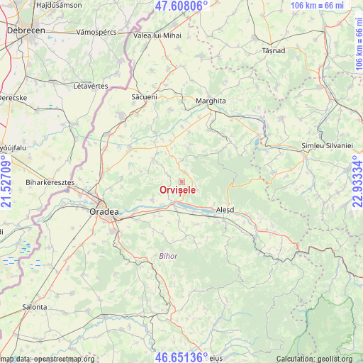
Orvișele GPS coordinates[2]
47° 7' 54.696" North, 22° 13' 48.756" East
| Map corner | latitude | longitude |
|---|---|---|
| Upper-left | 47.60806°, | 21.52709° |
| Center: | 47.13186°, | 22.23021° |
| Lower-right: | 46.65136°, | 22.93334° |
| Map W x H: | 106.4×106.4 km | = 66.1×66.1mi |
| max Lat: | 48.23793° ⇑17.9% North |
| Orvișele: | 47.13186° |
| min Lat: | ⇓82.1% South 43.65638° |
| min Long | Orvișele | max Long |
| 20.31667° | 22.23021° | 29.65403° |
| W 7.4%⇐ | ⇒92.6% E |
Elevation
Elevation of Orvișele is 171 m = 561 ft, and this is 83.9 m = 275 ft below average elevation for this country.
| Max E: |
1278 m = 4193 ft | 58.7% |
| Avg. | 254.9 m = 836 ft | |
| Orvișele | 171 m = 561 ft | |
Min E: |
-2 m = -7 ft | 41.3% |
See also: Romania elevation on elevation.city.
Geographical zone
Orvișele is located in North temperate zone (between Tropic of Cancer and the Arctic Circle). Distance of this North polar circle is 2160.6 km =1342.5 mi to North.| Distance of | km | miles | from Orvișele |
|---|---|---|---|
| North Pole | 4766.5 | 2961.8 | to North |
| Arctic Circle | 2160.6 | 1342.5 | to North |
| Tropic Cancer | 2634.7 | 1637.1 | to South |
| Equator | 5240.6 | 3256.4 | to South |


Nearby cities:
15 places around Orvișele: (largest is in red/bold)
• Botean
7.4 km =4.6 mi,  242°
242°
• Brusturi
2.5 km =1.6 mi,  36°
36°
• Burzuc
5.2 km =3.2 mi,  300°
300°
• Bălaia
5.1 km =3.2 mi, 239°
• Cuieșd
5.4 km =3.4 mi,  114°
114°
• Derna
9.2 km =5.7 mi,  34°
34°
• Dernișoara
10 km =6.2 mi,  9°
9°
• Picleu
2.7 km =1.7 mi,  58°
58°
• Sacalasău
8.4 km =5.2 mi, 30°
• Spinuş
7.9 km =4.9 mi,  343°
343°
• Săbolciu
8.7 km =5.4 mi,  222°
222°
• Telechiu
9.1 km =5.7 mi,  158°
158°
• Tileagd
7.6 km =4.7 mi,  197°
197°
• Uileacu de Criș
5.7 km =3.5 mi,  192°
192°
• Urvind
8.2 km =5.1 mi,  150°
150°
Sources, notices
• [Note1] Compared only with cities in Romania existing in our database
• [Src1] Map data: © OpenStreetMap contributors (CC-BY-SA)
• [Src2] Other city data from geonames.org with taken over terms of usage.
• [Src3] Geographical zone / Annual Mean Temperature by Robert A. Rohde @ Wikipedia
