Derna geodata
Derna (Bihor) is a seat of a second-order administrative division; located in Romania in Europe/Bucharest (GMT+3) time zone. With population of 2,963 people, there are 1804 cities with bigger population in this country. Compared to other cities in Romania, 83.9% of cities are located further ↓South; 91.7% of cities are located further →East and 51.8% of cities have higher elevation than Derna. Note1


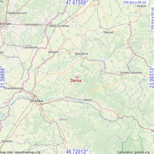
Derna GPS coordinates[2]
47° 12' 0" North, 22° 18' 0" East
| Map corner | latitude | longitude |
|---|---|---|
| Upper-left | 47.67558°, | 21.59688° |
| Center: | 47.2°, | 22.3° |
| Lower-right: | 46.72012°, | 23.00313° |
| Map W x H: | 106.2×106.2 km | = 66×66mi |
| max Lat: | 48.23793° ⇑16.1% North |
| Derna: | 47.2° |
| min Lat: | ⇓83.9% South 43.65638° |
| min Long | Derna | max Long |
| 20.31667° | 22.3° | 29.65403° |
| W 8.3%⇐ | ⇒91.7% E |
Elevation
Elevation of Derna is 202 m = 663 ft, and this is 52.9 m = 174 ft below average elevation for this country.
| Max E: |
1278 m = 4193 ft | 51.8% |
| Avg. | 254.9 m = 836 ft | |
| Derna | 202 m = 663 ft | |
Min E: |
-2 m = -7 ft | 48.2% |
See also: Romania elevation on elevation.city.
Geographical zone
Derna is located in North temperate zone (between Tropic of Cancer and the Arctic Circle). Distance of this North polar circle is 2153 km =1337.8 mi to North.| Distance of | km | miles | from Derna |
|---|---|---|---|
| North Pole | 4758.9 | 2957 | to North |
| Arctic Circle | 2153 | 1337.8 | to North |
| Tropic Cancer | 2642.2 | 1641.8 | to South |
| Equator | 5248.1 | 3261 | to South |


Nearby cities:
15 places around Derna: (largest is in red/bold)
• Bogei
8.6 km =5.3 mi,  32°
32°
• Brusturi
6.7 km =4.2 mi,  214°
214°
• Ciutelec
9.5 km =5.9 mi,  43°
43°
• Cuzap
8.7 km =5.4 mi,  87°
87°
• Dernișoara
4.2 km =2.6 mi,  302°
302°
• Mișca
7.6 km =4.7 mi,  336°
336°
• Orvișele
9.2 km =5.7 mi, 214°
• Picleu
6.8 km =4.2 mi, 205°
• Popeşti
9.6 km =6 mi,  67°
67°
• Pădurea Neagră
9.4 km =5.8 mi,  114°
114°
• Sacalasău
1.1 km =0.7 mi,  251°
251°
• Spinuş
7.6 km =4.7 mi,  270°
270°
• Tria
4.5 km =2.8 mi,  325°
325°
• Tăuteu
7.8 km =4.8 mi,  18°
18°
• Voivozi
7 km =4.3 mi,  75°
75°
Sources, notices
• [Note1] Compared only with cities in Romania existing in our database
• [Src1] Map data: © OpenStreetMap contributors (CC-BY-SA)
• [Src2] Other city data from geonames.org with taken over terms of usage.
• [Src3] Geographical zone / Annual Mean Temperature by Robert A. Rohde @ Wikipedia
