Ogra geodata
Ogra (Mureş) is a seat of a second-order administrative division; located in Romania in Europe/Bucharest (GMT+3) time zone. With population of 2,403 people, there are 2234 cities with bigger population in this country. Compared to other cities in Romania, 65.4% of cities are located further ↓South; 63.5% of cities are located further →East and 65.4% of cities have lower elevation than Ogra. Note1


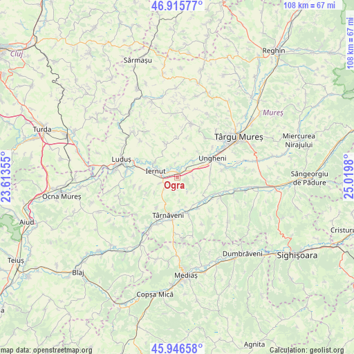
Ogra GPS coordinates[2]
46° 25' 59.988" North, 24° 19' 0.012" East
| Map corner | latitude | longitude |
|---|---|---|
| Upper-left | 46.91577°, | 23.61355° |
| Center: | 46.43333°, | 24.31667° |
| Lower-right: | 45.94658°, | 25.0198° |
| Map W x H: | 107.8×107.8 km | = 67×67mi |
| max Lat: | 48.23793° ⇑34.6% North |
| Ogra: | 46.43333° |
| min Lat: | ⇓65.4% South 43.65638° |
| min Long | Ogra | max Long |
| 20.31667° | 24.31667° | 29.65403° |
| W 36.5%⇐ | ⇒63.5% E |
Elevation
Elevation of Ogra is 292 m = 958 ft, and this is 37.1 m = 122 ft above average elevation for this country.
| Max E: |
1278 m = 4193 ft | 34.6% |
| Ogra | 292 m 958 ft | |
| Avg. | 254.9 m = 836 ft | |
Min E: |
-2 m = -7 ft | 65.4% |
See also: Romania elevation on elevation.city.
Geographical zone
Ogra is located in North temperate zone (between Tropic of Cancer and the Arctic Circle). Distance of this North polar circle is 2238.3 km =1390.8 mi to North.| Distance of | km | miles | from Ogra |
|---|---|---|---|
| North Pole | 4844.2 | 3010 | to North |
| Arctic Circle | 2238.3 | 1390.8 | to North |
| Tropic Cancer | 2557 | 1588.8 | to South |
| Equator | 5162.9 | 3208.1 | to South |


Nearby cities:
15 places around Ogra: (largest is in red/bold)
• Bobohalma
11.2 km =7 mi,  215°
215°
• Cerghid
10.1 km =6.3 mi,  101°
101°
• Cerghizel
10.1 km =6.3 mi,  83°
83°
• Chirileu
7 km =4.3 mi,  46°
46°
• Cipău
3.4 km =2.1 mi,  299°
299°
• Cucerdea
5.3 km =3.3 mi,  225°
225°
• Cuștelnic
10.5 km =6.5 mi,  182°
182°
• Iclandu Mare
11.2 km =7 mi,  339°
339°
• Iernut
5.4 km =3.4 mi,  289°
289°
• Lechința
8.1 km =5 mi, 303°
• Mica
10.7 km =6.6 mi,  134°
134°
• Sânpaul
3.2 km =2 mi, 54°
• Valea Izvoarelor
4.6 km =2.9 mi, 82°
• Vidrasău
8.9 km =5.5 mi,  58°
58°
• Șeulia de Mureș
5.7 km =3.5 mi,  249°
249°
Sources, notices
• [Note1] Compared only with cities in Romania existing in our database
• [Src1] Map data: © OpenStreetMap contributors (CC-BY-SA)
• [Src2] Other city data from geonames.org with taken over terms of usage.
• [Src3] Geographical zone / Annual Mean Temperature by Robert A. Rohde @ Wikipedia
