Cerghid geodata
Cerghid (Mureş) is a populated place; located in Romania in Europe/Bucharest (GMT+3) time zone. With population of 540 people, there are 6681 cities with bigger population in this country. Compared to other cities in Romania, 64.9% of cities are located further ↓South; 61% of cities are located further →East and 71.1% of cities have lower elevation than Cerghid. Note1


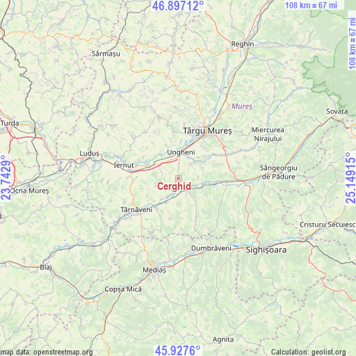
Cerghid GPS coordinates[2]
46° 24' 52.236" North, 24° 26' 45.672" East
| Map corner | latitude | longitude |
|---|---|---|
| Upper-left | 46.89712°, | 23.7429° |
| Center: | 46.41451°, | 24.44602° |
| Lower-right: | 45.9276°, | 25.14915° |
| Map W x H: | 107.8×107.8 km | = 67×67mi |
| max Lat: | 48.23793° ⇑35.1% North |
| Cerghid: | 46.41451° |
| min Lat: | ⇓64.9% South 43.65638° |
| min Long | Cerghid | max Long |
| 20.31667° | 24.44602° | 29.65403° |
| W 39%⇐ | ⇒61% E |
Elevation
Elevation of Cerghid is 328 m = 1076 ft, and this is 73.1 m = 240 ft above average elevation for this country.
| Max E: |
1278 m = 4193 ft | 28.9% |
| Cerghid | 328 m 1076 ft | |
| Avg. | 254.9 m = 836 ft | |
Min E: |
-2 m = -7 ft | 71.1% |
See also: Romania elevation on elevation.city.
Geographical zone
Cerghid is located in North temperate zone (between Tropic of Cancer and the Arctic Circle). Distance of this North polar circle is 2240.4 km =1392.1 mi to North.| Distance of | km | miles | from Cerghid |
|---|---|---|---|
| North Pole | 4846.3 | 3011.4 | to North |
| Arctic Circle | 2240.4 | 1392.1 | to North |
| Tropic Cancer | 2554.9 | 1587.5 | to South |
| Equator | 5160.8 | 3206.8 | to South |


Nearby cities:
15 places around Cerghid: (largest is in red/bold)
• Bahnea
6 km =3.7 mi,  151°
151°
• Cerghizel
3.2 km =2 mi,  2°
2°
• Ceuaș
7.9 km =4.9 mi,  181°
181°
• Chirileu
8.4 km =5.2 mi,  325°
325°
• Deaj
8.2 km =5.1 mi,  204°
204°
• Gheorghe Doja
7.1 km =4.4 mi,  35°
35°
• Idrifaia
3.3 km =2.1 mi, 154°
• Mica
5.8 km =3.6 mi, 202°
• Satu Nou
6.9 km =4.3 mi,  47°
47°
• Suplac
6.4 km =4 mi,  122°
122°
• Sânpaul
8.3 km =5.2 mi,  298°
298°
• Tirimia
5.2 km =3.2 mi, 42°
• Ungheni
7.8 km =4.8 mi,  11°
11°
• Valea Izvoarelor
6 km =3.7 mi, 296°
• Vidrasău
7.2 km =4.5 mi,  340°
340°
Sources, notices
• [Note1] Compared only with cities in Romania existing in our database
• [Src1] Map data: © OpenStreetMap contributors (CC-BY-SA)
• [Src2] Other city data from geonames.org with taken over terms of usage.
• [Src3] Geographical zone / Annual Mean Temperature by Robert A. Rohde @ Wikipedia
