Cerghizel geodata
Cerghizel (Mureş) is a populated place; located in Romania in Europe/Bucharest (GMT+3) time zone. With population of 740 people, there are 5340 cities with bigger population in this country. Compared to other cities in Romania, 65.6% of cities are located further ↓South; 61% of cities are located further →East and 69% of cities have lower elevation than Cerghizel. Note1


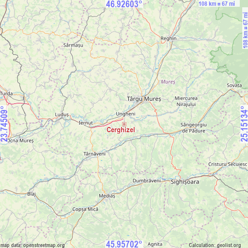
Cerghizel GPS coordinates[2]
46° 26' 37.248" North, 24° 26' 53.556" East
| Map corner | latitude | longitude |
|---|---|---|
| Upper-left | 46.92603°, | 23.74509° |
| Center: | 46.44368°, | 24.44821° |
| Lower-right: | 45.95702°, | 25.15134° |
| Map W x H: | 107.7×107.7 km | = 66.9×66.9mi |
| max Lat: | 48.23793° ⇑34.4% North |
| Cerghizel: | 46.44368° |
| min Lat: | ⇓65.6% South 43.65638° |
| min Long | Cerghizel | max Long |
| 20.31667° | 24.44821° | 29.65403° |
| W 39%⇐ | ⇒61% E |
Elevation
Elevation of Cerghizel is 312 m = 1024 ft, and this is 57.1 m = 187 ft above average elevation for this country.
| Max E: |
1278 m = 4193 ft | 31% |
| Cerghizel | 312 m 1024 ft | |
| Avg. | 254.9 m = 836 ft | |
Min E: |
-2 m = -7 ft | 69% |
See also: Romania elevation on elevation.city.
Geographical zone
Cerghizel is located in North temperate zone (between Tropic of Cancer and the Arctic Circle). Distance of this North polar circle is 2237.1 km =1390.1 mi to North.| Distance of | km | miles | from Cerghizel |
|---|---|---|---|
| North Pole | 4843 | 3009.3 | to North |
| Arctic Circle | 2237.1 | 1390.1 | to North |
| Tropic Cancer | 2558.1 | 1589.5 | to South |
| Equator | 5164.1 | 3208.8 | to South |


Nearby cities:
15 places around Cerghizel: (largest is in red/bold)
• Bahnea
9 km =5.6 mi,  162°
162°
• Cerghid
3.2 km =2 mi,  182°
182°
• Chirileu
6.2 km =3.9 mi,  306°
306°
• Cristeşti
6.8 km =4.2 mi,  23°
23°
• Gheorghe Doja
4.7 km =2.9 mi,  57°
57°
• Idrifaia
6.4 km =4 mi,  168°
168°
• Mica
8.9 km =5.5 mi,  195°
195°
• Odrihei
10.1 km =6.3 mi,  115°
115°
• Satu Nou
5.1 km =3.2 mi,  73°
73°
• Suplac
8.5 km =5.3 mi,  141°
141°
• Sânpaul
7.6 km =4.7 mi,  275°
275°
• Tirimia
3.4 km =2.1 mi,  79°
79°
• Ungheni
4.6 km =2.9 mi, 17°
• Valea Izvoarelor
5.6 km =3.5 mi,  264°
264°
• Vidrasău
4.3 km =2.7 mi,  324°
324°
Sources, notices
• [Note1] Compared only with cities in Romania existing in our database
• [Src1] Map data: © OpenStreetMap contributors (CC-BY-SA)
• [Src2] Other city data from geonames.org with taken over terms of usage.
• [Src3] Geographical zone / Annual Mean Temperature by Robert A. Rohde @ Wikipedia
