Odăile geodata
Odăile (Prahova) is a populated place; located in Romania in Europe/Bucharest (GMT+3) time zone. With population of 625 people, there are 6045 cities with bigger population in this country. Compared to other cities in Romania, 75.8% of cities are located further ↑North; 64.2% of cities are located further ←West and 75.1% of cities have higher elevation than Odăile. Note1


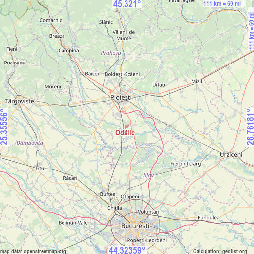
Odăile GPS coordinates[2]
44° 49' 28.02" North, 26° 3' 31.248" East
| Map corner | latitude | longitude |
|---|---|---|
| Upper-left | 45.321°, | 25.35556° |
| Center: | 44.82445°, | 26.05868° |
| Lower-right: | 44.32359°, | 26.76181° |
| Map W x H: | 110.9×110.9 km | = 68.9×68.9mi |
| max Lat: | 48.23793° ⇑75.8% North |
| Odăile: | 44.82445° |
| min Lat: | ⇓24.2% South 43.65638° |
| min Long | Odăile | max Long |
| 20.31667° | 26.05868° | 29.65403° |
| W 64.2%⇐ | ⇒35.8% E |
Elevation
Elevation of Odăile is 110 m = 361 ft, and this is 144.9 m = 475 ft below average elevation for this country.
| Max E: |
1278 m = 4193 ft | 75.1% |
| Avg. | 254.9 m = 836 ft | |
| Odăile | 110 m = 361 ft | |
Min E: |
-2 m = -7 ft | 24.9% |
See also: Romania elevation on elevation.city.
Geographical zone
Odăile is located in North temperate zone (between Tropic of Cancer and the Arctic Circle). Distance of this Northern Tropic circle is 2378.1 km =1477.7 mi to South.| Distance of | km | miles | from Odăile |
|---|---|---|---|
| North Pole | 5023.1 | 3121.2 | to North |
| Arctic Circle | 2417.2 | 1502 | to North |
| Tropic Cancer | 2378.1 | 1477.7 | to South |
| Equator | 4984 | 3096.9 | to South |


Nearby cities:
15 places around Odăile: (largest is in red/bold)
• Brazii de Jos
3.9 km =2.4 mi,  317°
317°
• Bătești
3 km =1.9 mi,  331°
331°
• Crivina
4.2 km =2.6 mi,  182°
182°
• Gorgota
5 km =3.1 mi,  156°
156°
• Miroslăvești
3.2 km =2 mi,  135°
135°
• Moara
1.3 km =0.8 mi,  36°
36°
• Pietroșani
3.9 km =2.4 mi,  64°
64°
• Pisculești
3.3 km =2.1 mi,  278°
278°
• Potigrafu
5.5 km =3.4 mi, 143°
• Predești
5.5 km =3.4 mi,  245°
245°
• Puchenii Mari
2.1 km =1.3 mi,  113°
113°
• Puchenii Mici
0.7 km =0.4 mi,  311°
311°
• Puchenii Moșneni
2.6 km =1.6 mi,  121°
121°
• Românești
4.7 km =2.9 mi,  7°
7°
• Tinosu
3.4 km =2.1 mi,  255°
255°
Sources, notices
• [Note1] Compared only with cities in Romania existing in our database
• [Src1] Map data: © OpenStreetMap contributors (CC-BY-SA)
• [Src2] Other city data from geonames.org with taken over terms of usage.
• [Src3] Geographical zone / Annual Mean Temperature by Robert A. Rohde @ Wikipedia
