Negoiești geodata
Negoiești (Prahova) is a populated place; located in Romania in Europe/Bucharest (GMT+3) time zone. With population of 1,858 people, there are 2752 cities with bigger population in this country. Compared to other cities in Romania, 74% of cities are located further ↑North; 62.5% of cities are located further ←West and 65.2% of cities have higher elevation than Negoiești. Note1


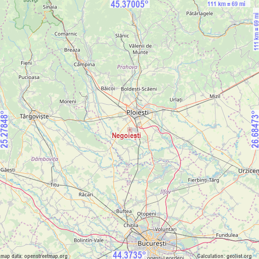
Negoiești GPS coordinates[2]
44° 52' 26.148" North, 25° 58' 53.76" East
| Map corner | latitude | longitude |
|---|---|---|
| Upper-left | 45.37005°, | 25.27848° |
| Center: | 44.87393°, | 25.9816° |
| Lower-right: | 44.3735°, | 26.68473° |
| Map W x H: | 110.8×110.8 km | = 68.8×68.8mi |
| max Lat: | 48.23793° ⇑74% North |
| Negoiești: | 44.87393° |
| min Lat: | ⇓26% South 43.65638° |
| min Long | Negoiești | max Long |
| 20.31667° | 25.9816° | 29.65403° |
| W 62.5%⇐ | ⇒37.5% E |
Elevation
Elevation of Negoiești is 146 m = 479 ft, and this is 108.9 m = 357 ft below average elevation for this country.
| Max E: |
1278 m = 4193 ft | 65.2% |
| Avg. | 254.9 m = 836 ft | |
| Negoiești | 146 m = 479 ft | |
Min E: |
-2 m = -7 ft | 34.8% |
See also: Romania elevation on elevation.city.
Geographical zone
Negoiești is located in North temperate zone (between Tropic of Cancer and the Arctic Circle). Distance of this Northern Tropic circle is 2383.6 km =1481.1 mi to South.| Distance of | km | miles | from Negoiești |
|---|---|---|---|
| North Pole | 5017.5 | 3117.7 | to North |
| Arctic Circle | 2411.7 | 1498.6 | to North |
| Tropic Cancer | 2383.6 | 1481.1 | to South |
| Equator | 4989.5 | 3100.3 | to South |


Nearby cities:
15 places around Negoiești: (largest is in red/bold)
• Brazii de Jos
4.3 km =2.7 mi,  127°
127°
• Brazii de Sus
2.9 km =1.8 mi,  106°
106°
• Bărcăneşti
5.5 km =3.4 mi,  79°
79°
• Bătești
5.4 km =3.4 mi,  121°
121°
• Cocorăștii Colț
7.8 km =4.8 mi,  235°
235°
• Pisculești
5.7 km =3.5 mi,  150°
150°
• Popești
1.8 km =1.1 mi,  143°
143°
• Puchenii Mici
7.5 km =4.7 mi, 132°
• Românești
6.8 km =4.2 mi,  96°
96°
• Stejaru
4.3 km =2.7 mi,  201°
201°
• Strejnicu
5.3 km =3.3 mi,  333°
333°
• Stăncești
5.6 km =3.5 mi,  248°
248°
• Tinosu
6.9 km =4.3 mi,  156°
156°
• Târgşoru Vechi
5.2 km =3.2 mi,  261°
261°
• Tătărani
5 km =3.1 mi,  57°
57°
Sources, notices
• [Note1] Compared only with cities in Romania existing in our database
• [Src1] Map data: © OpenStreetMap contributors (CC-BY-SA)
• [Src2] Other city data from geonames.org with taken over terms of usage.
• [Src3] Geographical zone / Annual Mean Temperature by Robert A. Rohde @ Wikipedia
