Stejaru geodata
Stejaru (Prahova) is a populated place; located in Romania in Europe/Bucharest (GMT+3) time zone. With population of 590 people, there are 6285 cities with bigger population in this country. Compared to other cities in Romania, 75.3% of cities are located further ↑North; 62.1% of cities are located further ←West and 65.4% of cities have higher elevation than Stejaru. Note1


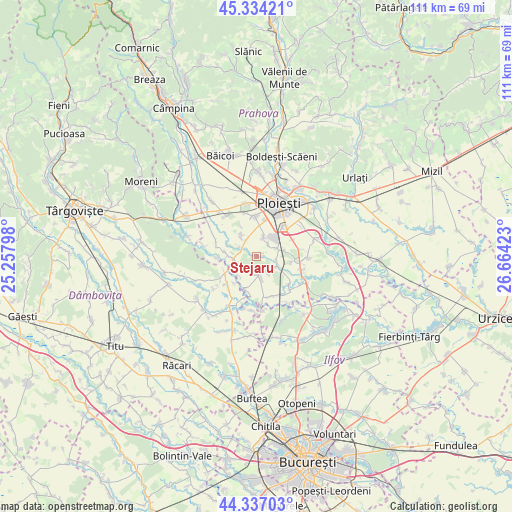
Stejaru GPS coordinates[2]
44° 50' 16.008" North, 25° 57' 39.96" East
| Map corner | latitude | longitude |
|---|---|---|
| Upper-left | 45.33421°, | 25.25798° |
| Center: | 44.83778°, | 25.9611° |
| Lower-right: | 44.33703°, | 26.66423° |
| Map W x H: | 110.9×110.9 km | = 68.9×68.9mi |
| max Lat: | 48.23793° ⇑75.3% North |
| Stejaru: | 44.83778° |
| min Lat: | ⇓24.7% South 43.65638° |
| min Long | Stejaru | max Long |
| 20.31667° | 25.9611° | 29.65403° |
| W 62.1%⇐ | ⇒37.9% E |
Elevation
Elevation of Stejaru is 145 m = 476 ft, and this is 109.9 m = 361 ft below average elevation for this country.
| Max E: |
1278 m = 4193 ft | 65.4% |
| Avg. | 254.9 m = 836 ft | |
| Stejaru | 145 m = 476 ft | |
Min E: |
-2 m = -7 ft | 34.6% |
See also: Romania elevation on elevation.city.
Geographical zone
Stejaru is located in North temperate zone (between Tropic of Cancer and the Arctic Circle). Distance of this Northern Tropic circle is 2379.6 km =1478.6 mi to South.| Distance of | km | miles | from Stejaru |
|---|---|---|---|
| North Pole | 5021.6 | 3120.3 | to North |
| Arctic Circle | 2415.7 | 1501 | to North |
| Tropic Cancer | 2379.6 | 1478.6 | to South |
| Equator | 4985.5 | 3097.8 | to South |


Nearby cities:
15 places around Stejaru: (largest is in red/bold)
• Brazii de Jos
5.3 km =3.3 mi,  74°
74°
• Brazii de Sus
5.4 km =3.4 mi,  53°
53°
• Brătești
5.4 km =3.4 mi,  221°
221°
• Bătești
6.4 km =4 mi,  79°
79°
• Cocorăștii Colț
4.9 km =3 mi,  265°
265°
• Negoiești
4.3 km =2.7 mi,  21°
21°
• Pisculești
4.5 km =2.8 mi,  102°
102°
• Popești
3.7 km =2.3 mi, 46°
• Predești
4.7 km =2.9 mi,  144°
144°
• Stăncești
4.1 km =2.5 mi,  298°
298°
• Tinosu
5 km =3.1 mi,  118°
118°
• Târgşoru Vechi
4.8 km =3 mi,  312°
312°
• Tăriceni
4.7 km =2.9 mi,  171°
171°
• Varnița
3.7 km =2.3 mi,  199°
199°
• Şirna
4.3 km =2.7 mi,  191°
191°
Sources, notices
• [Note1] Compared only with cities in Romania existing in our database
• [Src1] Map data: © OpenStreetMap contributors (CC-BY-SA)
• [Src2] Other city data from geonames.org with taken over terms of usage.
• [Src3] Geographical zone / Annual Mean Temperature by Robert A. Rohde @ Wikipedia
