Târgşoru Vechi geodata
Târgşoru Vechi (Prahova) is a seat of a second-order administrative division; located in Romania in Europe/Bucharest (GMT+3) time zone. With population of 8,460 people, there are 278 cities with bigger population in this country. Compared to other cities in Romania, 74.4% of cities are located further ↑North; 61.3% of cities are located further ←West and 61.1% of cities have higher elevation than Târgşoru Vechi. Note1


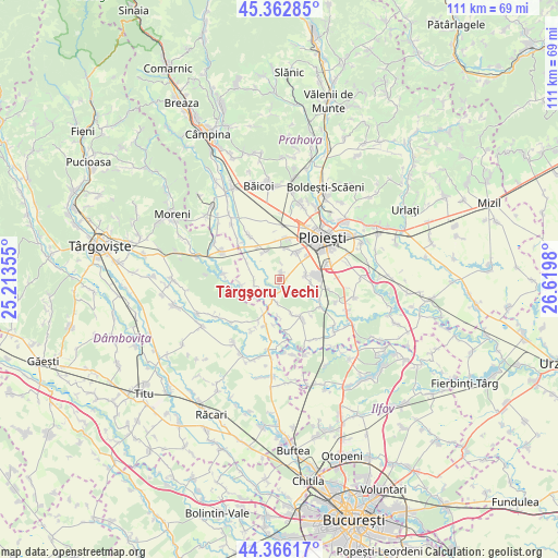
Târgşoru Vechi GPS coordinates[2]
44° 52' 0.012" North, 25° 55' 0.012" East
| Map corner | latitude | longitude |
|---|---|---|
| Upper-left | 45.36285°, | 25.21355° |
| Center: | 44.86667°, | 25.91667° |
| Lower-right: | 44.36617°, | 26.6198° |
| Map W x H: | 110.8×110.8 km | = 68.8×68.8mi |
| max Lat: | 48.23793° ⇑74.4% North |
| Târgşoru Vechi: | 44.86667° |
| min Lat: | ⇓25.6% South 43.65638° |
| min Long | Târgşoru Vech | max Long |
| 20.31667° | 25.91667° | 29.65403° |
| W 61.3%⇐ | ⇒38.7% E |
Elevation
Elevation of Târgşoru Vechi is 162 m = 531 ft, and this is 92.9 m = 305 ft below average elevation for this country.
| Max E: |
1278 m = 4193 ft | 61.1% |
| Avg. | 254.9 m = 836 ft | |
| Târgşoru Vechi | 162 m = 531 ft | |
Min E: |
-2 m = -7 ft | 38.9% |
See also: Romania elevation on elevation.city.
Geographical zone
Târgşoru Vechi is located in North temperate zone (between Tropic of Cancer and the Arctic Circle). Distance of this Northern Tropic circle is 2382.8 km =1480.6 mi to South.| Distance of | km | miles | from Târgşoru Vechi |
|---|---|---|---|
| North Pole | 5018.4 | 3118.3 | to North |
| Arctic Circle | 2412.5 | 1499.1 | to North |
| Tropic Cancer | 2382.8 | 1480.6 | to South |
| Equator | 4988.7 | 3099.8 | to South |


Nearby cities:
15 places around Târgşoru Vechi: (largest is in red/bold)
• Brazii de Sus
7.9 km =4.9 mi,  90°
90°
• Brătești
7.2 km =4.5 mi,  180°
180°
• Băltița
6 km =3.7 mi,  237°
237°
• Coada Izvorului
7.8 km =4.8 mi,  262°
262°
• Cocorăștii Colț
3.9 km =2.4 mi,  200°
200°
• Cocorăștii Grind
3.8 km =2.4 mi, 235°
• Măneşti
5.3 km =3.3 mi,  270°
270°
• Negoiești
5.2 km =3.2 mi,  81°
81°
• Popești
6.3 km =3.9 mi,  96°
96°
• Postârnacu
6.1 km =3.8 mi,  205°
205°
• Stejaru
4.8 km =3 mi,  132°
132°
• Strejnicu
6.2 km =3.9 mi,  25°
25°
• Stăncești
1.3 km =0.8 mi, 183°
• Varnița
7 km =4.3 mi,  161°
161°
• Zalhanaua
7.8 km =4.8 mi,  300°
300°
Sources, notices
• [Note1] Compared only with cities in Romania existing in our database
• [Src1] Map data: © OpenStreetMap contributors (CC-BY-SA)
• [Src2] Other city data from geonames.org with taken over terms of usage.
• [Src3] Geographical zone / Annual Mean Temperature by Robert A. Rohde @ Wikipedia
