Mogoşeşti-Siret geodata
Mogoşeşti-Siret (Iaşi) is a seat of a second-order administrative division; located in Romania in Europe/Bucharest (GMT+3) time zone. With population of 4,044 people, there are 1146 cities with bigger population in this country. Compared to other cities in Romania, 82.2% of cities are located further ↓South; 78.3% of cities are located further ←West and 53.5% of cities have lower elevation than Mogoşeşti-Siret. Note1


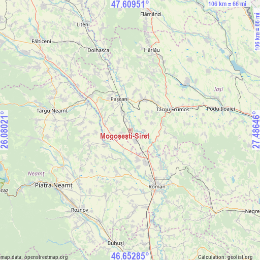
Mogoşeşti-Siret GPS coordinates[2]
47° 7' 59.988" North, 26° 46' 59.988" East
| Map corner | latitude | longitude |
|---|---|---|
| Upper-left | 47.60951°, | 26.08021° |
| Center: | 47.13333°, | 26.78333° |
| Lower-right: | 46.65285°, | 27.48646° |
| Map W x H: | 106.4×106.4 km | = 66.1×66.1mi |
| max Lat: | 48.23793° ⇑17.8% North |
| Mogoşeşti-Siret: | 47.13333° |
| min Lat: | ⇓82.2% South 43.65638° |
| min Long | Mogoşeşti-Sir | max Long |
| 20.31667° | 26.78333° | 29.65403° |
| W 78.3%⇐ | ⇒21.7% E |
Elevation
Elevation of Mogoşeşti-Siret is 231 m = 758 ft, and this is 23.9 m = 78 ft below average elevation for this country.
| Max E: |
1278 m = 4193 ft | 46.5% |
| Avg. | 254.9 m = 836 ft | |
| Mogoşeşti-Siret | 231 m = 758 ft | |
Min E: |
-2 m = -7 ft | 53.5% |
See also: Romania elevation on elevation.city.
Geographical zone
Mogoşeşti-Siret is located in North temperate zone (between Tropic of Cancer and the Arctic Circle). Distance of this North polar circle is 2160.4 km =1342.4 mi to North.| Distance of | km | miles | from Mogoşeşti-Siret |
|---|---|---|---|
| North Pole | 4766.3 | 2961.6 | to North |
| Arctic Circle | 2160.4 | 1342.4 | to North |
| Tropic Cancer | 2634.8 | 1637.2 | to South |
| Equator | 5240.7 | 3256.4 | to South |


Nearby cities:
15 places around Mogoşeşti-Siret: (largest is in red/bold)
• Alexandru I. Cuza
5 km =3.1 mi,  90°
90°
• Barticești
7.8 km =4.8 mi,  174°
174°
• Botești
9.4 km =5.8 mi,  196°
196°
• Ciohorăni
7.1 km =4.4 mi,  271°
271°
• Fărcășeni
9 km =5.6 mi,  70°
70°
• Hălăuceşti
3.9 km =2.4 mi,  161°
161°
• Hărmăneasa
9.7 km =6 mi,  40°
40°
• Luncași
2.5 km =1.6 mi,  136°
136°
• Mirceşti
6.7 km =4.2 mi,  145°
145°
• Muncelu de Sus
3.8 km =2.4 mi,  253°
253°
• Nisiporești
7.1 km =4.4 mi,  208°
208°
• Oboroceni
8.6 km =5.3 mi,  55°
55°
• Scheia
7.6 km =4.7 mi,  103°
103°
• Stolniceni-Prăjescu
7.7 km =4.8 mi,  339°
339°
• Tudor Vladimirescu
0.2 km =0.1 mi, 85°
Sources, notices
• [Note1] Compared only with cities in Romania existing in our database
• [Src1] Map data: © OpenStreetMap contributors (CC-BY-SA)
• [Src2] Other city data from geonames.org with taken over terms of usage.
• [Src3] Geographical zone / Annual Mean Temperature by Robert A. Rohde @ Wikipedia
