Oboroceni geodata
Oboroceni (Iaşi) is a populated place; located in Romania in Europe/Bucharest (GMT+3) time zone. With population of 859 people, there are 4794 cities with bigger population in this country. Compared to other cities in Romania, 83.3% of cities are located further ↓South; 80.4% of cities are located further ←West and 58.3% of cities have lower elevation than Oboroceni. Note1


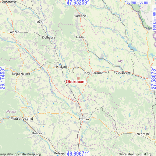
Oboroceni GPS coordinates[2]
47° 10' 36.48" North, 26° 52' 39.54" East
| Map corner | latitude | longitude |
|---|---|---|
| Upper-left | 47.65259°, | 26.17453° |
| Center: | 47.1768°, | 26.87765° |
| Lower-right: | 46.69671°, | 27.58078° |
| Map W x H: | 106.3×106.3 km | = 66.1×66.1mi |
| max Lat: | 48.23793° ⇑16.7% North |
| Oboroceni: | 47.1768° |
| min Lat: | ⇓83.3% South 43.65638° |
| min Long | Oboroceni | max Long |
| 20.31667° | 26.87765° | 29.65403° |
| W 80.4%⇐ | ⇒19.6% E |
Elevation
Elevation of Oboroceni is 254 m = 833 ft, and this is 0.90000000000001 m = 3 ft below average elevation for this country.
| Max E: |
1278 m = 4193 ft | 41.7% |
| Avg. | 254.9 m = 836 ft | |
| Oboroceni | 254 m = 833 ft | |
Min E: |
-2 m = -7 ft | 58.3% |
See also: Romania elevation on elevation.city.
Geographical zone
Oboroceni is located in North temperate zone (between Tropic of Cancer and the Arctic Circle). Distance of this North polar circle is 2155.6 km =1339.4 mi to North.| Distance of | km | miles | from Oboroceni |
|---|---|---|---|
| North Pole | 4761.5 | 2958.7 | to North |
| Arctic Circle | 2155.6 | 1339.4 | to North |
| Tropic Cancer | 2639.6 | 1640.2 | to South |
| Equator | 5245.6 | 3259.5 | to South |


Nearby cities:
15 places around Oboroceni: (largest is in red/bold)
• Alexandru I. Cuza
5.3 km =3.3 mi,  203°
203°
• Brătulești
9 km =5.6 mi,  129°
129°
• Costești
7.4 km =4.6 mi,  29°
29°
• Dumbrăvița
9.1 km =5.7 mi,  342°
342°
• Fărcășeni
2.3 km =1.4 mi,  143°
143°
• Giurgești
8.5 km =5.3 mi,  16°
16°
• Heleșteni
2.9 km =1.8 mi,  359°
359°
• Hărmăneasa
2.7 km =1.7 mi, 342°
• Luncași
8.6 km =5.3 mi,  219°
219°
• Mogoşeşti-Siret
8.6 km =5.3 mi,  235°
235°
• Rediu
7.1 km =4.4 mi,  351°
351°
• Ruginoasa
8.4 km =5.2 mi, 345°
• Scheia
6.6 km =4.1 mi,  177°
177°
• Strunga
8.1 km =5 mi,  98°
98°
• Tudor Vladimirescu
8.5 km =5.3 mi, 235°
Sources, notices
• [Note1] Compared only with cities in Romania existing in our database
• [Src1] Map data: © OpenStreetMap contributors (CC-BY-SA)
• [Src2] Other city data from geonames.org with taken over terms of usage.
• [Src3] Geographical zone / Annual Mean Temperature by Robert A. Rohde @ Wikipedia
