Stolniceni-Prăjescu geodata
Stolniceni-Prăjescu (Iaşi) is a seat of a second-order administrative division; located in Romania in Europe/Bucharest (GMT+3) time zone. With population of 5,625 people, there are 614 cities with bigger population in this country. Compared to other cities in Romania, 83.8% of cities are located further ↓South; 77.5% of cities are located further ←West and 55.2% of cities have lower elevation than Stolniceni-Prăjescu. Note1


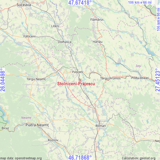
Stolniceni-Prăjescu GPS coordinates[2]
47° 11' 54.888" North, 26° 44' 53.16" East
| Map corner | latitude | longitude |
|---|---|---|
| Upper-left | 47.67418°, | 26.04498° |
| Center: | 47.19858°, | 26.7481° |
| Lower-right: | 46.71868°, | 27.45123° |
| Map W x H: | 106.2×106.2 km | = 66×66mi |
| max Lat: | 48.23793° ⇑16.2% North |
| Stolniceni-Prăjescu: | 47.19858° |
| min Lat: | ⇓83.8% South 43.65638° |
| min Long | Stolniceni-Pră | max Long |
| 20.31667° | 26.7481° | 29.65403° |
| W 77.5%⇐ | ⇒22.5% E |
Elevation
Elevation of Stolniceni-Prăjescu is 239 m = 784 ft, and this is 15.9 m = 52 ft below average elevation for this country.
| Max E: |
1278 m = 4193 ft | 44.8% |
| Avg. | 254.9 m = 836 ft | |
| Stolniceni-Prăjescu | 239 m = 784 ft | |
Min E: |
-2 m = -7 ft | 55.2% |
See also: Romania elevation on elevation.city.
Geographical zone
Stolniceni-Prăjescu is located in North temperate zone (between Tropic of Cancer and the Arctic Circle). Distance of this North polar circle is 2153.2 km =1337.9 mi to North.| Distance of | km | miles | from Stolniceni-Prăjescu |
|---|---|---|---|
| North Pole | 4759.1 | 2957.2 | to North |
| Arctic Circle | 2153.2 | 1337.9 | to North |
| Tropic Cancer | 2642.1 | 1641.7 | to South |
| Equator | 5248 | 3261 | to South |


Nearby cities:
15 places around Stolniceni-Prăjescu: (largest is in red/bold)
• Boureni
9 km =5.6 mi,  280°
280°
• Brătești
4.8 km =3 mi,  260°
260°
• Ciohorăni
8.3 km =5.2 mi,  212°
212°
• Dumbrăvița
9.4 km =5.8 mi,  48°
48°
• Hărmăneasa
9 km =5.6 mi,  88°
88°
• Hărmăneștii Noi
7.2 km =4.5 mi,  32°
32°
• Lunca
9.3 km =5.8 mi,  354°
354°
• Miroslovești
9.2 km =5.7 mi,  233°
233°
• Mogoşeşti-Siret
7.7 km =4.8 mi,  159°
159°
• Muncelu de Sus
8.4 km =5.2 mi,  186°
186°
• Paşcani
5.7 km =3.5 mi,  340°
340°
• Soci
8 km =5 mi, 259°
• Sodomeni
5.2 km =3.2 mi,  300°
300°
• Topile
9.4 km =5.8 mi,  320°
320°
• Tudor Vladimirescu
7.8 km =4.8 mi, 158°
Sources, notices
• [Note1] Compared only with cities in Romania existing in our database
• [Src1] Map data: © OpenStreetMap contributors (CC-BY-SA)
• [Src2] Other city data from geonames.org with taken over terms of usage.
• [Src3] Geographical zone / Annual Mean Temperature by Robert A. Rohde @ Wikipedia
