Mânăstioara geodata
Mânăstioara (Dâmboviţa) is a populated place; located in Romania in Europe/Bucharest (GMT+3) time zone. With population of 739 people, there are 5345 cities with bigger population in this country. Compared to other cities in Romania, 82.5% of cities are located further ↑North; 53.3% of cities are located further ←West and 61.4% of cities have higher elevation than Mânăstioara. Note1


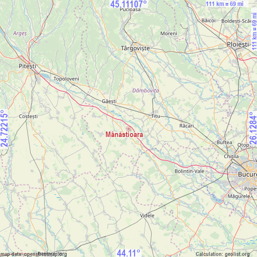
Mânăstioara GPS coordinates[2]
44° 36' 45.684" North, 25° 25' 30.972" East
| Map corner | latitude | longitude |
|---|---|---|
| Upper-left | 45.11107°, | 24.72215° |
| Center: | 44.61269°, | 25.42527° |
| Lower-right: | 44.11°, | 26.1284° |
| Map W x H: | 111.3×111.3 km | = 69.2×69.2mi |
| max Lat: | 48.23793° ⇑82.5% North |
| Mânăstioara: | 44.61269° |
| min Lat: | ⇓17.5% South 43.65638° |
| min Long | Mânăstioara | max Long |
| 20.31667° | 25.42527° | 29.65403° |
| W 53.3%⇐ | ⇒46.7% E |
Elevation
Elevation of Mânăstioara is 161 m = 528 ft, and this is 93.9 m = 308 ft below average elevation for this country.
| Max E: |
1278 m = 4193 ft | 61.4% |
| Avg. | 254.9 m = 836 ft | |
| Mânăstioara | 161 m = 528 ft | |
Min E: |
-2 m = -7 ft | 38.6% |
See also: Romania elevation on elevation.city.
Geographical zone
Mânăstioara is located in North temperate zone (between Tropic of Cancer and the Arctic Circle). Distance of this Northern Tropic circle is 2354.5 km =1463 mi to South.| Distance of | km | miles | from Mânăstioara |
|---|---|---|---|
| North Pole | 5046.6 | 3135.8 | to North |
| Arctic Circle | 2440.7 | 1516.6 | to North |
| Tropic Cancer | 2354.5 | 1463 | to South |
| Equator | 4960.5 | 3082.3 | to South |


Nearby cities:
15 places around Mânăstioara: (largest is in red/bold)
• Broșteni
6.1 km =3.8 mi,  263°
263°
• Costeştii din Vale
6.2 km =3.9 mi,  47°
47°
• Croitori
4.3 km =2.7 mi,  192°
192°
• Grozăvești
5.4 km =3.4 mi,  155°
155°
• Izvoru
4.1 km =2.5 mi, 264°
• Jugureni
2 km =1.2 mi,  305°
305°
• Mărunțișu
6.6 km =4.1 mi,  75°
75°
• Petrești
6.4 km =4 mi, 163°
• Poroinica
5.9 km =3.7 mi,  17°
17°
• Puțu cu Salcie
5.1 km =3.2 mi,  29°
29°
• Ragu
2.5 km =1.6 mi,  228°
228°
• Satu Nou
4.6 km =2.9 mi,  113°
113°
• Tomșani
6.9 km =4.3 mi,  62°
62°
• Ulieşti
3.3 km =2.1 mi, 191°
• Zăvoiu
5.6 km =3.5 mi,  342°
342°
Sources, notices
• [Note1] Compared only with cities in Romania existing in our database
• [Src1] Map data: © OpenStreetMap contributors (CC-BY-SA)
• [Src2] Other city data from geonames.org with taken over terms of usage.
• [Src3] Geographical zone / Annual Mean Temperature by Robert A. Rohde @ Wikipedia
