Merghindeal geodata
Merghindeal (Sibiu) is a seat of a second-order administrative division; located in Romania in Europe/Bucharest (GMT+3) time zone. With population of 1,256 people, there are 3627 cities with bigger population in this country. Compared to other cities in Romania, 54.3% of cities are located further ↓South; 56.6% of cities are located further →East and 87% of cities have lower elevation than Merghindeal. Note1


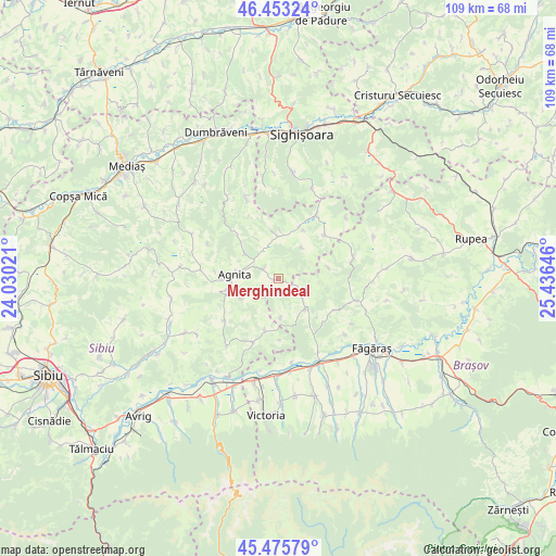
Merghindeal GPS coordinates[2]
45° 58' 0.012" North, 24° 43' 59.988" East
| Map corner | latitude | longitude |
|---|---|---|
| Upper-left | 46.45324°, | 24.03021° |
| Center: | 45.96667°, | 24.73333° |
| Lower-right: | 45.47579°, | 25.43646° |
| Map W x H: | 108.7×108.7 km | = 67.5×67.5mi |
| max Lat: | 48.23793° ⇑45.7% North |
| Merghindeal: | 45.96667° |
| min Lat: | ⇓54.3% South 43.65638° |
| min Long | Merghindeal | max Long |
| 20.31667° | 24.73333° | 29.65403° |
| W 43.4%⇐ | ⇒56.6% E |
Elevation
Elevation of Merghindeal is 469 m = 1539 ft, and this is 214.1 m = 702 ft above average elevation for this country.
| Max E: |
1278 m = 4193 ft | 13% |
| Merghindeal | 469 m 1539 ft | |
| Avg. | 254.9 m = 836 ft | |
Min E: |
-2 m = -7 ft | 87% |
See also: Romania elevation on elevation.city.
Geographical zone
Merghindeal is located in North temperate zone (between Tropic of Cancer and the Arctic Circle). Distance of this North polar circle is 2290.2 km =1423.1 mi to North.| Distance of | km | miles | from Merghindeal |
|---|---|---|---|
| North Pole | 4896 | 3042.2 | to North |
| Arctic Circle | 2290.2 | 1423.1 | to North |
| Tropic Cancer | 2505.1 | 1556.6 | to South |
| Equator | 5111 | 3175.8 | to South |


Nearby cities:
15 places around Merghindeal: (largest is in red/bold)
• Agnita
9 km =5.6 mi,  270°
270°
• Apold
17.9 km =11.1 mi,  21°
21°
• Bruiu
11.4 km =7.1 mi,  193°
193°
• Brădeni
15.1 km =9.4 mi,  30°
30°
• Bârghiş
15.6 km =9.7 mi,  276°
276°
• Chirpăr
12.7 km =7.9 mi,  234°
234°
• Cincu
7.6 km =4.7 mi,  137°
137°
• Cincșor
16.3 km =10.1 mi,  151°
151°
• Coveș
12.5 km =7.8 mi, 277°
• Dealu Frumos
3.5 km =2.2 mi,  305°
305°
• Iacobeni
9.4 km =5.8 mi,  352°
352°
• Mălâncrav
17.2 km =10.7 mi,  337°
337°
• Retiș
12.5 km =7.8 mi,  46°
46°
• Ruja
8.1 km =5 mi, 308°
• Şoarş
15.7 km =9.8 mi,  105°
105°
Sources, notices
• [Note1] Compared only with cities in Romania existing in our database
• [Src1] Map data: © OpenStreetMap contributors (CC-BY-SA)
• [Src2] Other city data from geonames.org with taken over terms of usage.
• [Src3] Geographical zone / Annual Mean Temperature by Robert A. Rohde @ Wikipedia
