Şoarş geodata
Şoarş (Braşov) is a seat of a second-order administrative division; located in Romania in Europe/Bucharest (GMT+3) time zone. With population of 1,870 people, there are 2735 cities with bigger population in this country. Compared to other cities in Romania, 53.5% of cities are located further ↓South; 53.7% of cities are located further →East and 87.9% of cities have lower elevation than Şoarş. Note1


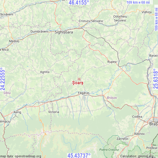
Şoarş GPS coordinates[2]
45° 55' 42.924" North, 24° 55' 43.212" East
| Map corner | latitude | longitude |
|---|---|---|
| Upper-left | 46.4155°, | 24.22555° |
| Center: | 45.92859°, | 24.92867° |
| Lower-right: | 45.43737°, | 25.6318° |
| Map W x H: | 108.8×108.8 km | = 67.6×67.6mi |
| max Lat: | 48.23793° ⇑46.5% North |
| Şoarş: | 45.92859° |
| min Lat: | ⇓53.5% South 43.65638° |
| min Long | Şoarş | max Long |
| 20.31667° | 24.92867° | 29.65403° |
| W 46.3%⇐ | ⇒53.7% E |
Elevation
Elevation of Şoarş is 481 m = 1578 ft, and this is 226.1 m = 742 ft above average elevation for this country.
| Max E: |
1278 m = 4193 ft | 12.1% |
| Şoarş | 481 m 1578 ft | |
| Avg. | 254.9 m = 836 ft | |
Min E: |
-2 m = -7 ft | 87.9% |
See also: Romania elevation on elevation.city.
Geographical zone
Şoarş is located in North temperate zone (between Tropic of Cancer and the Arctic Circle). Distance of this North polar circle is 2294.4 km =1425.7 mi to North.| Distance of | km | miles | from Şoarş |
|---|---|---|---|
| North Pole | 4900.3 | 3044.9 | to North |
| Arctic Circle | 2294.4 | 1425.7 | to North |
| Tropic Cancer | 2500.9 | 1554 | to South |
| Equator | 5106.8 | 3173.2 | to South |


Nearby cities:
15 places around Şoarş: (largest is in red/bold)
• Beclean
10.8 km =6.7 mi,  182°
182°
• Cincu
10 km =6.2 mi,  262°
262°
• Cincșor
12.6 km =7.8 mi,  216°
216°
• Făgăraș
9.2 km =5.7 mi,  161°
161°
• Grânari
12.9 km =8 mi,  15°
15°
• Hălmeag
17.3 km =10.7 mi,  113°
113°
• Ileni
16.7 km =10.4 mi, 160°
• Jibert
13.3 km =8.3 mi,  53°
53°
• Merghindeal
15.7 km =9.8 mi,  285°
285°
• Mândra
15.6 km =9.7 mi,  142°
142°
• Retiș
14.1 km =8.8 mi,  334°
334°
• Sâmbăta de Jos
15.5 km =9.6 mi,  212°
212°
• Ticuşu Vechi
13.3 km =8.3 mi,  87°
87°
• Voila
14 km =8.7 mi, 208°
• Voivodeni
17.3 km =10.7 mi,  197°
197°
Sources, notices
• [Note1] Compared only with cities in Romania existing in our database
• [Src1] Map data: © OpenStreetMap contributors (CC-BY-SA)
• [Src2] Other city data from geonames.org with taken over terms of usage.
• [Src3] Geographical zone / Annual Mean Temperature by Robert A. Rohde @ Wikipedia
