Melicești geodata
Melicești (Prahova) is a populated place; located in Romania in Europe/Bucharest (GMT+3) time zone. With population of 665 people, there are 5780 cities with bigger population in this country. Compared to other cities in Romania, 63.1% of cities are located further ↑North; 59.4% of cities are located further ←West and 92.5% of cities have lower elevation than Melicești. Note1


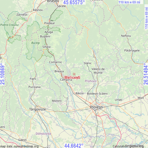
Melicești GPS coordinates[2]
45° 9' 43.668" North, 25° 48' 42.516" East
| Map corner | latitude | longitude |
|---|---|---|
| Upper-left | 45.65575°, | 25.10869° |
| Center: | 45.16213°, | 25.81181° |
| Lower-right: | 44.6642°, | 26.51494° |
| Map W x H: | 110.3×110.2 km | = 68.5×68.5mi |
| max Lat: | 48.23793° ⇑63.1% North |
| Melicești: | 45.16213° |
| min Lat: | ⇓36.9% South 43.65638° |
| min Long | Melicești | max Long |
| 20.31667° | 25.81181° | 29.65403° |
| W 59.4%⇐ | ⇒40.6% E |
Elevation
Elevation of Melicești is 558 m = 1831 ft, and this is 303.1 m = 994 ft above average elevation for this country.
| Max E: |
1278 m = 4193 ft | 7.5% |
| Melicești | 558 m 1831 ft | |
| Avg. | 254.9 m = 836 ft | |
Min E: |
-2 m = -7 ft | 92.5% |
See also: Romania elevation on elevation.city.
Geographical zone
Melicești is located in North temperate zone (between Tropic of Cancer and the Arctic Circle). Distance of this North polar circle is 2379.6 km =1478.6 mi to North.| Distance of | km | miles | from Melicești |
|---|---|---|---|
| North Pole | 4985.5 | 3097.8 | to North |
| Arctic Circle | 2379.6 | 1478.6 | to North |
| Tropic Cancer | 2415.6 | 1501 | to South |
| Equator | 5021.6 | 3120.3 | to South |


Nearby cities:
15 places around Melicești: (largest is in red/bold)
• Aluniş
6 km =3.7 mi,  45°
45°
• Brebu Megieșesc
3 km =1.9 mi,  282°
282°
• Brebu Mânăstirei
4.3 km =2.7 mi,  303°
303°
• Buștenari
2.9 km =1.8 mi,  142°
142°
• Băneşti
7.8 km =4.8 mi,  207°
207°
• Cosmina de Jos
5.8 km =3.6 mi,  103°
103°
• Câmpina
7.2 km =4.5 mi,  236°
236°
• Doftana
1.6 km =1 mi, 214°
• Lunca Mare
6.7 km =4.2 mi,  308°
308°
• Mislea
7.3 km =4.5 mi,  172°
172°
• Pietriceaua
6.3 km =3.9 mi,  357°
357°
• Plaiu Câmpinei
6.6 km =4.1 mi,  290°
290°
• Scorţeni
7.5 km =4.7 mi,  156°
156°
• Telega
3.9 km =2.4 mi, 214°
• Urleta
8.4 km =5.2 mi,  189°
189°
Sources, notices
• [Note1] Compared only with cities in Romania existing in our database
• [Src1] Map data: © OpenStreetMap contributors (CC-BY-SA)
• [Src2] Other city data from geonames.org with taken over terms of usage.
• [Src3] Geographical zone / Annual Mean Temperature by Robert A. Rohde @ Wikipedia
