Doftana geodata
Doftana (Prahova) is a populated place; located in Romania in Europe/Bucharest (GMT+3) time zone. With population of 6,777 people, there are 431 cities with bigger population in this country. Compared to other cities in Romania, 63.6% of cities are located further ↑North; 59.1% of cities are located further ←West and 90.3% of cities have lower elevation than Doftana. Note1


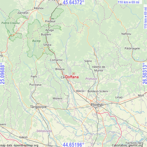
Doftana GPS coordinates[2]
45° 9' 0" North, 25° 48' 0" East
| Map corner | latitude | longitude |
|---|---|---|
| Upper-left | 45.64372°, | 25.09688° |
| Center: | 45.15°, | 25.8° |
| Lower-right: | 44.65196°, | 26.50313° |
| Map W x H: | 110.3×110.3 km | = 68.5×68.5mi |
| max Lat: | 48.23793° ⇑63.6% North |
| Doftana: | 45.15° |
| min Lat: | ⇓36.4% South 43.65638° |
| min Long | Doftana | max Long |
| 20.31667° | 25.8° | 29.65403° |
| W 59.1%⇐ | ⇒40.9% E |
Elevation
Elevation of Doftana is 517 m = 1696 ft, and this is 262.1 m = 860 ft above average elevation for this country.
| Max E: |
1278 m = 4193 ft | 9.7% |
| Doftana | 517 m 1696 ft | |
| Avg. | 254.9 m = 836 ft | |
Min E: |
-2 m = -7 ft | 90.3% |
See also: Romania elevation on elevation.city.
Geographical zone
Doftana is located in North temperate zone (between Tropic of Cancer and the Arctic Circle). Distance of this North polar circle is 2381 km =1479.5 mi to North.| Distance of | km | miles | from Doftana |
|---|---|---|---|
| North Pole | 4986.9 | 3098.7 | to North |
| Arctic Circle | 2381 | 1479.5 | to North |
| Tropic Cancer | 2414.3 | 1500.2 | to South |
| Equator | 5020.2 | 3119.4 | to South |


Nearby cities:
15 places around Doftana: (largest is in red/bold)
• Aluniş
7.6 km =4.7 mi,  43°
43°
• Brebu Megieșesc
2.8 km =1.7 mi,  314°
314°
• Brebu Mânăstirei
4.5 km =2.8 mi,  324°
324°
• Buștenari
2.9 km =1.8 mi,  109°
109°
• Băneşti
6.1 km =3.8 mi,  205°
205°
• Cornu de Jos
7.5 km =4.7 mi,  275°
275°
• Cosmina de Jos
6.5 km =4 mi,  90°
90°
• Câmpina
5.7 km =3.5 mi,  242°
242°
• Lunca Mare
7 km =4.3 mi, 321°
• Melicești
1.6 km =1 mi,  34°
34°
• Mislea
6.2 km =3.9 mi,  162°
162°
• Plaiu Câmpinei
6.4 km =4 mi, 305°
• Scorţeni
6.8 km =4.2 mi,  144°
144°
• Telega
2.3 km =1.4 mi,  215°
215°
• Urleta
7 km =4.3 mi,  184°
184°
Sources, notices
• [Note1] Compared only with cities in Romania existing in our database
• [Src1] Map data: © OpenStreetMap contributors (CC-BY-SA)
• [Src2] Other city data from geonames.org with taken over terms of usage.
• [Src3] Geographical zone / Annual Mean Temperature by Robert A. Rohde @ Wikipedia
