Mărgheni geodata
Mărgheni (Olt) is a populated place; located in Romania in Europe/Bucharest (GMT+3) time zone. With population of 868 people, there are 4762 cities with bigger population in this country. Compared to other cities in Romania, 90.1% of cities are located further ↑North; 62.6% of cities are located further →East and 79% of cities have higher elevation than Mărgheni. Note1


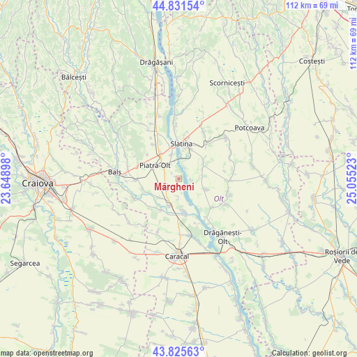
Mărgheni GPS coordinates[2]
44° 19' 50.664" North, 24° 21' 7.56" East
| Map corner | latitude | longitude |
|---|---|---|
| Upper-left | 44.83154°, | 23.64898° |
| Center: | 44.33074°, | 24.3521° |
| Lower-right: | 43.82563°, | 25.05523° |
| Map W x H: | 111.8×111.8 km | = 69.5×69.5mi |
| max Lat: | 48.23793° ⇑90.1% North |
| Mărgheni: | 44.33074° |
| min Lat: | ⇓9.9% South 43.65638° |
| min Long | Mărgheni | max Long |
| 20.31667° | 24.3521° | 29.65403° |
| W 37.4%⇐ | ⇒62.6% E |
Elevation
Elevation of Mărgheni is 98 m = 322 ft, and this is 156.9 m = 515 ft below average elevation for this country.
| Max E: |
1278 m = 4193 ft | 79% |
| Avg. | 254.9 m = 836 ft | |
| Mărgheni | 98 m = 322 ft | |
Min E: |
-2 m = -7 ft | 21% |
See also: Romania elevation on elevation.city.
Geographical zone
Mărgheni is located in North temperate zone (between Tropic of Cancer and the Arctic Circle). Distance of this Northern Tropic circle is 2323.2 km =1443.6 mi to South.| Distance of | km | miles | from Mărgheni |
|---|---|---|---|
| North Pole | 5077.9 | 3155.3 | to North |
| Arctic Circle | 2472.1 | 1536.1 | to North |
| Tropic Cancer | 2323.2 | 1443.6 | to South |
| Equator | 4929.1 | 3062.8 | to South |


Nearby cities:
15 places around Mărgheni: (largest is in red/bold)
• Brebeni
8.7 km =5.4 mi,  62°
62°
• Brâncoveni
4.4 km =2.7 mi,  249°
249°
• Criva de Jos
5.3 km =3.3 mi,  325°
325°
• Criva de Sus
5.8 km =3.6 mi, 332°
• Greci
5.5 km =3.4 mi,  179°
179°
• Ipotești
3.9 km =2.4 mi,  98°
98°
• Milcovu din Deal
7.7 km =4.8 mi,  22°
22°
• Ociogi
1.2 km =0.7 mi,  187°
187°
• Piatra
5.6 km =3.5 mi,  306°
306°
• Piatra Olt
7.9 km =4.9 mi,  300°
300°
• Slătioara
8.2 km =5.1 mi,  339°
339°
• Ulmi
4.1 km =2.5 mi,  29°
29°
• Vlăduleni
8.4 km =5.2 mi, 193°
• Văleni
5.3 km =3.3 mi,  223°
223°
• Şopârliţa
7.6 km =4.7 mi,  226°
226°
Sources, notices
• [Note1] Compared only with cities in Romania existing in our database
• [Src1] Map data: © OpenStreetMap contributors (CC-BY-SA)
• [Src2] Other city data from geonames.org with taken over terms of usage.
• [Src3] Geographical zone / Annual Mean Temperature by Robert A. Rohde @ Wikipedia
