Brebeni geodata
Brebeni (Olt) is a seat of a second-order administrative division; located in Romania in Europe/Bucharest (GMT+3) time zone. With population of 2,904 people, there are 1847 cities with bigger population in this country. Compared to other cities in Romania, 89.2% of cities are located further ↑North; 60.9% of cities are located further →East and 69.6% of cities have higher elevation than Brebeni. Note1


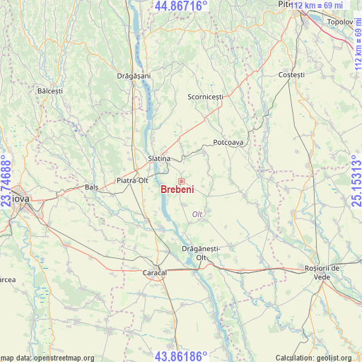
Brebeni GPS coordinates[2]
44° 22' 0.012" North, 24° 27' 0" East
| Map corner | latitude | longitude |
|---|---|---|
| Upper-left | 44.86716°, | 23.74688° |
| Center: | 44.36667°, | 24.45° |
| Lower-right: | 43.86186°, | 25.15313° |
| Map W x H: | 111.8×111.8 km | = 69.5×69.5mi |
| max Lat: | 48.23793° ⇑89.2% North |
| Brebeni: | 44.36667° |
| min Lat: | ⇓10.8% South 43.65638° |
| min Long | Brebeni | max Long |
| 20.31667° | 24.45° | 29.65403° |
| W 39.1%⇐ | ⇒60.9% E |
Elevation
Elevation of Brebeni is 129 m = 423 ft, and this is 125.9 m = 413 ft below average elevation for this country.
| Max E: |
1278 m = 4193 ft | 69.6% |
| Avg. | 254.9 m = 836 ft | |
| Brebeni | 129 m = 423 ft | |
Min E: |
-2 m = -7 ft | 30.4% |
See also: Romania elevation on elevation.city.
Geographical zone
Brebeni is located in North temperate zone (between Tropic of Cancer and the Arctic Circle). Distance of this Northern Tropic circle is 2327.2 km =1446.1 mi to South.| Distance of | km | miles | from Brebeni |
|---|---|---|---|
| North Pole | 5074 | 3152.8 | to North |
| Arctic Circle | 2468.1 | 1533.6 | to North |
| Tropic Cancer | 2327.2 | 1446.1 | to South |
| Equator | 4933.1 | 3065.3 | to South |


Nearby cities:
15 places around Brebeni: (largest is in red/bold)
• Bârca
9.3 km =5.8 mi,  2°
2°
• Catanele
9 km =5.6 mi,  79°
79°
• Coteana
7.5 km =4.7 mi,  169°
169°
• Greci
9.6 km =6 mi,  114°
114°
• Ipotești
6 km =3.7 mi,  220°
220°
• Lisa
6.8 km =4.2 mi,  103°
103°
• Mierleștii de Sus
9.7 km =6 mi,  63°
63°
• Milcovu din Deal
5.7 km =3.5 mi,  302°
302°
• Măgura
8.9 km =5.5 mi,  70°
70°
• Mărgheni
8.7 km =5.4 mi,  242°
242°
• Ociogi
9.5 km =5.9 mi, 236°
• Perieţi
8.8 km =5.5 mi, 64°
• Schitu
9.5 km =5.9 mi, 101°
• Turia
9.2 km =5.7 mi,  13°
13°
• Ulmi
5.7 km =3.5 mi,  265°
265°
Sources, notices
• [Note1] Compared only with cities in Romania existing in our database
• [Src1] Map data: © OpenStreetMap contributors (CC-BY-SA)
• [Src2] Other city data from geonames.org with taken over terms of usage.
• [Src3] Geographical zone / Annual Mean Temperature by Robert A. Rohde @ Wikipedia
