Ipotești geodata
Ipotești (Olt) is a seat of a second-order administrative division; located in Romania in Europe/Bucharest (GMT+3) time zone. With population of 1,519 people, there are 3141 cities with bigger population in this country. Compared to other cities in Romania, 90.2% of cities are located further ↑North; 61.7% of cities are located further →East and 73.9% of cities have higher elevation than Ipotești. Note1


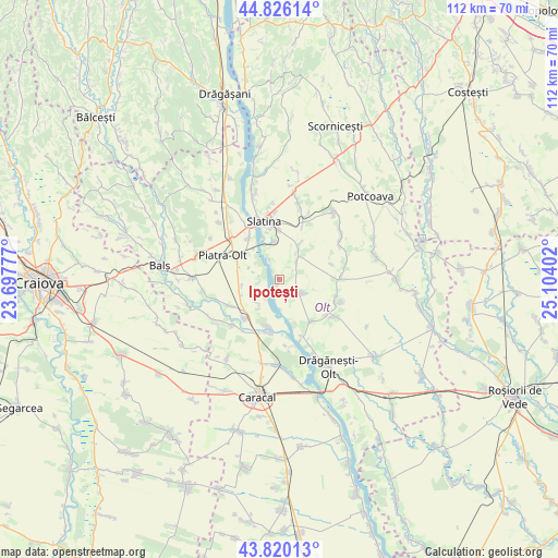
Ipotești GPS coordinates[2]
44° 19' 31.044" North, 24° 24' 3.204" East
| Map corner | latitude | longitude |
|---|---|---|
| Upper-left | 44.82614°, | 23.69777° |
| Center: | 44.32529°, | 24.40089° |
| Lower-right: | 43.82013°, | 25.10402° |
| Map W x H: | 111.9×111.9 km | = 69.5×69.5mi |
| max Lat: | 48.23793° ⇑90.2% North |
| Ipotești: | 44.32529° |
| min Lat: | ⇓9.8% South 43.65638° |
| min Long | Ipotești | max Long |
| 20.31667° | 24.40089° | 29.65403° |
| W 38.3%⇐ | ⇒61.7% E |
Elevation
Elevation of Ipotești is 114 m = 374 ft, and this is 140.9 m = 462 ft below average elevation for this country.
| Max E: |
1278 m = 4193 ft | 73.9% |
| Avg. | 254.9 m = 836 ft | |
| Ipotești | 114 m = 374 ft | |
Min E: |
-2 m = -7 ft | 26.1% |
See also: Romania elevation on elevation.city.
Geographical zone
Ipotești is located in North temperate zone (between Tropic of Cancer and the Arctic Circle). Distance of this Northern Tropic circle is 2322.6 km =1443.2 mi to South.| Distance of | km | miles | from Ipotești |
|---|---|---|---|
| North Pole | 5078.6 | 3155.7 | to North |
| Arctic Circle | 2472.7 | 1536.5 | to North |
| Tropic Cancer | 2322.6 | 1443.2 | to South |
| Equator | 4928.5 | 3062.4 | to South |


Nearby cities:
15 places around Ipotești: (largest is in red/bold)
• Brebeni
6 km =3.7 mi,  40°
40°
• Brâncoveni
8.1 km =5 mi,  263°
263°
• Cioroiașu
9.5 km =5.9 mi,  195°
195°
• Cioroiu
9.7 km =6 mi,  189°
189°
• Coteana
5.9 km =3.7 mi,  118°
118°
• Criva de Jos
8.5 km =5.3 mi,  305°
305°
• Criva de Sus
8.7 km =5.4 mi, 311°
• Greci
6.2 km =3.9 mi,  218°
218°
• Milcovu din Deal
7.8 km =4.8 mi,  353°
353°
• Mărgheni
3.9 km =2.4 mi,  278°
278°
• Ociogi
4.1 km =2.5 mi, 261°
• Piatra
9.2 km =5.7 mi,  295°
295°
• Ulmi
4.6 km =2.9 mi,  336°
336°
• Vlăduleni
9.6 km =6 mi, 217°
• Văleni
8.2 km =5.1 mi,  246°
246°
Sources, notices
• [Note1] Compared only with cities in Romania existing in our database
• [Src1] Map data: © OpenStreetMap contributors (CC-BY-SA)
• [Src2] Other city data from geonames.org with taken over terms of usage.
• [Src3] Geographical zone / Annual Mean Temperature by Robert A. Rohde @ Wikipedia
