Măgureni geodata
Măgureni (Prahova) is a seat of a second-order administrative division; located in Romania in Europe/Bucharest (GMT+3) time zone. With population of 6,515 people, there are 469 cities with bigger population in this country. Compared to other cities in Romania, 67.1% of cities are located further ↑North; 57.9% of cities are located further ←West and 76.5% of cities have lower elevation than Măgureni. Note1


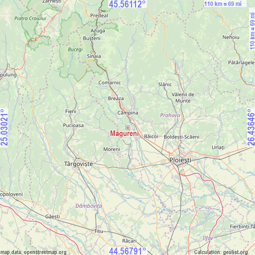
Măgureni GPS coordinates[2]
45° 4' 0.012" North, 25° 43' 59.988" East
| Map corner | latitude | longitude |
|---|---|---|
| Upper-left | 45.56112°, | 25.03021° |
| Center: | 45.06667°, | 25.73333° |
| Lower-right: | 44.56791°, | 26.43646° |
| Map W x H: | 110.4×110.4 km | = 68.6×68.6mi |
| max Lat: | 48.23793° ⇑67.1% North |
| Măgureni: | 45.06667° |
| min Lat: | ⇓32.9% South 43.65638° |
| min Long | Măgureni | max Long |
| 20.31667° | 25.73333° | 29.65403° |
| W 57.9%⇐ | ⇒42.1% E |
Elevation
Elevation of Măgureni is 364 m = 1194 ft, and this is 109.1 m = 358 ft above average elevation for this country.
| Max E: |
1278 m = 4193 ft | 23.5% |
| Măgureni | 364 m 1194 ft | |
| Avg. | 254.9 m = 836 ft | |
Min E: |
-2 m = -7 ft | 76.5% |
See also: Romania elevation on elevation.city.
Geographical zone
Măgureni is located in North temperate zone (between Tropic of Cancer and the Arctic Circle). Distance of this North polar circle is 2390.2 km =1485.2 mi to North.| Distance of | km | miles | from Măgureni |
|---|---|---|---|
| North Pole | 4996.1 | 3104.4 | to North |
| Arctic Circle | 2390.2 | 1485.2 | to North |
| Tropic Cancer | 2405 | 1494.4 | to South |
| Equator | 5010.9 | 3113.6 | to South |


Nearby cities:
15 places around Măgureni: (largest is in red/bold)
• Bobolia
3.1 km =1.9 mi,  13°
13°
• Băneşti
4.5 km =2.8 mi,  35°
35°
• Cocorăștii Caplii
2.2 km =1.4 mi,  89°
89°
• Câmpina
6.6 km =4.1 mi,  1°
1°
• Cătina
7.5 km =4.7 mi,  147°
147°
• Drăgăneasa
5.9 km =3.7 mi,  316°
316°
• Filipeştii de Pădure
7.5 km =4.7 mi,  169°
169°
• Floreşti
4.3 km =2.7 mi,  115°
115°
• Lunca Prahovei
3.7 km =2.3 mi,  125°
125°
• Mislea
7.9 km =4.9 mi,  64°
64°
• Novăcești
5.7 km =3.5 mi,  141°
141°
• Poiana Câmpina
8.4 km =5.2 mi,  332°
332°
• Telega
8.4 km =5.2 mi,  27°
27°
• Tufeni
8.4 km =5.2 mi,  96°
96°
• Urleta
5.3 km =3.3 mi, 64°
Sources, notices
• [Note1] Compared only with cities in Romania existing in our database
• [Src1] Map data: © OpenStreetMap contributors (CC-BY-SA)
• [Src2] Other city data from geonames.org with taken over terms of usage.
• [Src3] Geographical zone / Annual Mean Temperature by Robert A. Rohde @ Wikipedia
