Belinţ geodata
Belinţ (Timiş) is a seat of a second-order administrative division; located in Romania in Europe/Bucharest (GMT+3) time zone. With population of 3,023 people, there are 1744 cities with bigger population in this country. Compared to other cities in Romania, 50.7% of cities are located further ↑North; 96.1% of cities are located further →East and 76.3% of cities have higher elevation than Belinţ. Note1


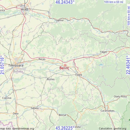
Belinţ GPS coordinates[2]
45° 45' 18" North, 21° 45' 37.008" East
| Map corner | latitude | longitude |
|---|---|---|
| Upper-left | 46.24343°, | 21.05716° |
| Center: | 45.755°, | 21.76028° |
| Lower-right: | 45.26225°, | 22.46341° |
| Map W x H: | 109.1×109.1 km | = 67.8×67.8mi |
| max Lat: | 48.23793° ⇑50.7% North |
| Belinţ: | 45.755° |
| min Lat: | ⇓49.3% South 43.65638° |
| min Long | Belinţ | max Long |
| 20.31667° | 21.76028° | 29.65403° |
| W 3.9%⇐ | ⇒96.1% E |
Elevation
Elevation of Belinţ is 106 m = 348 ft, and this is 148.9 m = 489 ft below average elevation for this country.
| Max E: |
1278 m = 4193 ft | 76.3% |
| Avg. | 254.9 m = 836 ft | |
| Belinţ | 106 m = 348 ft | |
Min E: |
-2 m = -7 ft | 23.7% |
See also: Romania elevation on elevation.city.
Geographical zone
Belinţ is located in North temperate zone (between Tropic of Cancer and the Arctic Circle). Distance of this North polar circle is 2313.7 km =1437.7 mi to North.| Distance of | km | miles | from Belinţ |
|---|---|---|---|
| North Pole | 4919.6 | 3056.9 | to North |
| Arctic Circle | 2313.7 | 1437.7 | to North |
| Tropic Cancer | 2481.6 | 1542 | to South |
| Equator | 5087.5 | 3161.2 | to South |


Nearby cities:
15 places around Belinţ: (largest is in red/bold)
• Balinţ
9.7 km =6 mi,  48°
48°
• Bodo
11.7 km =7.3 mi, 54°
• Boldur
6.9 km =4.3 mi,  169°
169°
• Chizătău
2.2 km =1.4 mi,  267°
267°
• Coşteiu
7.1 km =4.4 mi,  102°
102°
• Darova
12.6 km =7.8 mi,  175°
175°
• Darova Nouă
13.5 km =8.4 mi, 177°
• Ghizela
7.9 km =4.9 mi,  346°
346°
• Iosifalău
6.8 km =4.2 mi,  295°
295°
• Lugoj
13.3 km =8.3 mi,  123°
123°
• Ohaba-Forgaci
4.3 km =2.7 mi,  200°
200°
• Racoviţa
11.5 km =7.1 mi,  236°
236°
• Sinersig
9.5 km =5.9 mi, 197°
• Topolovăţu Mare
11.2 km =7 mi,  280°
280°
• Șanovița
5.3 km =3.3 mi,  334°
334°
Sources, notices
• [Note1] Compared only with cities in Romania existing in our database
• [Src1] Map data: © OpenStreetMap contributors (CC-BY-SA)
• [Src2] Other city data from geonames.org with taken over terms of usage.
• [Src3] Geographical zone / Annual Mean Temperature by Robert A. Rohde @ Wikipedia
